


openlayers加载低版本arcgis server发布的wmts无法加载/加载偏移问题
openlayer加载常规ogc标准的wmts往往只需要指定默认的resolutions和matrixIds即可
resolutions = [
      0.703125, 0.3515625, 0.17578125, 0.087890625, 0.0439453125, 0.02197265625,
      0.010986328125, 0.0054931640625, 0.00274658203125, 0.001373291015625,
      0.0006866455078125, 3.4332275390625e-4, 1.71661376953125e-4,
      8.58306884765625e-5, 4.291534423828125e-5, 2.145767211914063e-5,
      1.072883605957031e-5, 5.364418029785156e-6, 2.682209014892578e-6,
    ];
	for (let z = 0; z < 14; ++z) {
      // generate resolutions and matrixIds arrays for this WMTS
      // resolutions[z] = size / Math.pow(2, z);
      matrixIds[z] = z;
    }
但是在加载某些特殊的图层时,会遇到使用默认参数无法加载的情况,这时我们需要通过GetCapabilities获取xml文档查看图层信息,如下图所示:
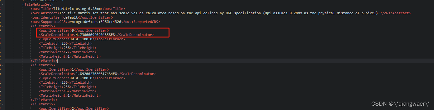
某些图层每一级别都有自定义的比例尺信息,我们用默认的resolutions肯定加载不出来,这时我们需要根据ScaleDenominator(比例尺分母)去计算对应级别下的resolution.
  const DPI = 90.7142857142857
  const inch = 0.0254
  const degree2MeterParams = 111319.49
  const projection = getProjection('EPSG:4326');
  const projectionExtent = projection.getExtent();
  const size = getWidth(projectionExtent) / 256;
  let resolutions = [];
  const matrixIds = [];
  for (let z = 0; z < options.scaleDenominators.length; ++z) {
     // generate resolutions and matrixIds arrays for this WMTS
     const meter = options.scaleDenominators[z] * inch / DPI;
     resolutions[z] =  meter / degree2MeterParams;
     matrixIds[z] = z;
  }
注意其中的degree2MeterParams 变量,arcgis10.4以下的版本使用的度转米参数是111194.65,而标准的WMTS使用的参数是111319.49,如果使用arcgis的参数会导致与天地图叠加偏移
以上就是关于openlayer加载arcgis wmts相关问题的记录了.
参考文章:
- https://blog.youkuaiyun.com/supermapsupport/article/details/122069280
- https://blog.youkuaiyun.com/chijingjing/article/details/105486393
- https://www.cnblogs.com/oloroso/p/14156002.html
- https://blog.youkuaiyun.com/nj198624/article/details/8172559


 981
981

 被折叠的 条评论
为什么被折叠?
被折叠的 条评论
为什么被折叠?
 到【灌水乐园】发言


