


 超级会员免费看
Principle
Any gray image can be regarded as a topological plane, the region with high gray value can be regarded as a mountain peak, and the region with low gray value can be regarded as a valley.
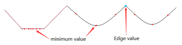
When we pour different colors of water into every valley, the water in different valleys will meet and converge with the water level rises. In order to prevent the water in different valleys from converging, we need to build dams where the water converges.keep pouring water and building dykes until all the mountains are flooded. The dam we built is the segmentation of the image.
 OpenCV中的Watershed算法将灰度图像视为地形,高灰度区域为山峰,低灰度区域为山谷。随着水位上升,不同山谷的水会相遇并汇聚。为了避免不同山谷的水交汇,需要在交汇处筑坝。最终形成的大坝即为图像的分割。然而,这通常会导致过度分割。为减少这种影响,OpenCV采用基于掩模的Watershed算法,预先设定哪些山谷点会交汇,哪些不会。该过程需要对已知对象进行不同标记,确定的前景区域用一种颜色标签,背景区域用另一种,不确定的区域标记为0。然后执行Watershed算法,每次灌溉更新标签,不同颜色标签相遇时筑坝,直到所有区域被淹没,最后得到边界对象(大坝)值为-1。步骤包括获取灰度图像、二值图像、形态学降噪、膨胀背景、距离变换、设置种子等。

 订阅专栏 解锁全文


 768
768

 被折叠的 条评论
为什么被折叠?
被折叠的 条评论
为什么被折叠?
 到【灌水乐园】发言


