 地理坐标转换与计算


 本文介绍了如何使用Python进行地理坐标系间的转换,包括从大地坐标系到ECEF坐标系的转换,反之亦然。此外还提供了计算两地之间的距离及方位角的方法。
在定位与地图构建领域,有时候会需要进行各种地理坐标系之间的转换,以及如何计算各种地理信息!下面是我使用python来实现的计算方法,各位适当参考!
参考资料:
https://www.movable-type.co.uk/scripts/latlong.html
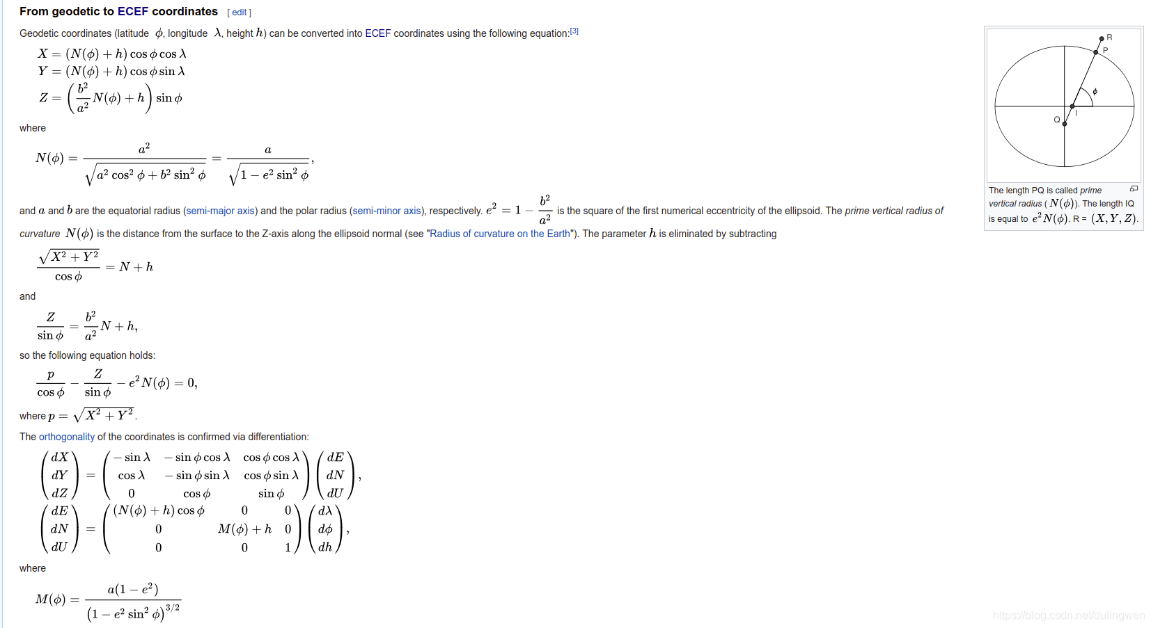
https://en.wikipedia.org/wiki/Geographic_coordinate_conversion#From_geodetic_to_ECEF_coordinates
1.将大地坐标系坐标转换为ECEF坐标系坐标
大地坐标系坐标一般为经度、维度、海拔,是球坐标系,而ECEF坐标系为笛卡尔坐标系,该转换方法是基于地球为椭球来进行转换的。
原理如下:
# latitude:纬度 longitude:经度 altitude:海拔
def LLA_to_XYZ(latitude, longitude, altitude):
    # 经纬度的余弦值
    cosLat = math.cos(latitude * math.pi / 180)
    sinLat = math.sin(latitude * math.pi / 180)
    cosLon = math.cos(longitude * math.pi / 180)
    sinLon = math.sin(longitude * math.pi / 180)

    # WGS84坐标系的参数
    rad = 6378137.0        #地球赤道平均半径(椭球长半轴:a)
    f = 1.0 / 298.257224   # WGS84椭球扁率 :f = (a-b)/a
    C = 1.0 / math.sqrt(cosLat * cosLat + (1-f) * (1-f) * sinLat * sinLat)
    S = (1-f) * (1-f) * C
    h = altitude

    # 计算XYZ坐标
    X = (rad * C + h) * cosLat * cosLon
    Y = (rad * C + h) * cosLat * sinLon
    Z = (rad * S + h) * sinLat

    return np.array([X, Y, Z])
2.将ECEF坐标系转换为大地坐标系
def XYZ_to_LLA(X, Y, Z):
    # WGS84坐标系的参数
    a = 6378137.0        # 椭球长半轴
    b = 6356752.314245   # 椭球短半轴
    ea = np.sqrt((a ** 2 - b ** 2) / a ** 2)
    eb = np.sqrt((a ** 2 - b ** 2) / b ** 2)
    p = np.sqrt(X ** 2 + Y ** 2)
    theta = np.arctan2(Z * a, p * b)

    # 计算经纬度及海拔
    longitude = np.arctan2(Y, X)
    latitude = np.arctan2(Z + eb ** 2 * b * np.sin(theta) ** 3, p - ea ** 2 * a * np.cos(theta) ** 3)
    N = a / np.sqrt(1 - ea ** 2 * np.sin(latitude) ** 2)
    altitude = p / np.cos(latitude) - N

    return np.array([np.degrees(latitude), np.degrees(longitude), altitude])
3.根据经度、纬度、海拔计算两地距离
# 根据经度、纬度、海拔计算两地距离:法一
def get_distance1(position1, position2):
    v1 = LLA_to_XYZ(position1[0], position1[1], position1[2])
    v2 = LLA_to_XYZ(position2[0], position2[1], position2[2])
    distance = np.linalg.norm(v1 - v2)

    return distance


# 根据经度、纬度计算两地距离:法二
def get_distance2(lat1, lon1, lat2, lon2):
    """获取地理坐标系下的两点间距离"""
    # GetDistanceInGeographyCoordinate, return two point distance
    radius_lat1 = lat1 * math.pi / 180
    radius_lat2 = lat2 * math.pi / 180
    radius_lon1 = lon1 * math.pi / 180
    radius_lon2 = lon2 * math.pi / 180
    a = radius_lat1 - radius_lat2
    b = radius_lon1 - radius_lon2
    distance = 2 * math.asin(math.sqrt(
        pow(math.sin(a / 2.0), 2) +
        math.cos(radius_lat1) * math.cos(radius_lat2) *
        pow(math.sin(b / 2.0), 2)))

    distance = distance * 6378137
    distance = distance - (distance * 0.0011194)
    return distance
4.根据两地经纬度计算方位角
def get_bearing(lat1, lon1, lat2, lon2):
    dlon = lon2 - lon1

    y = math.sin(dlon) * math.cos(lat2)
    x = math.cos(lat1) * math.sin(lat2) - math.sin(lat1) * math.cos(lat2) * math.cos(dlon)

    bearing = math.atan2(y, x)
    bearing = np.degrees(bearing)
    bearing = (bearing + 360) % 360

    return bearing
5.由A地的经纬度,A、B两地的方位角、距离,计算B点的经纬度
略!后续补充!


 1万+
1万+


 到【灌水乐园】发言


