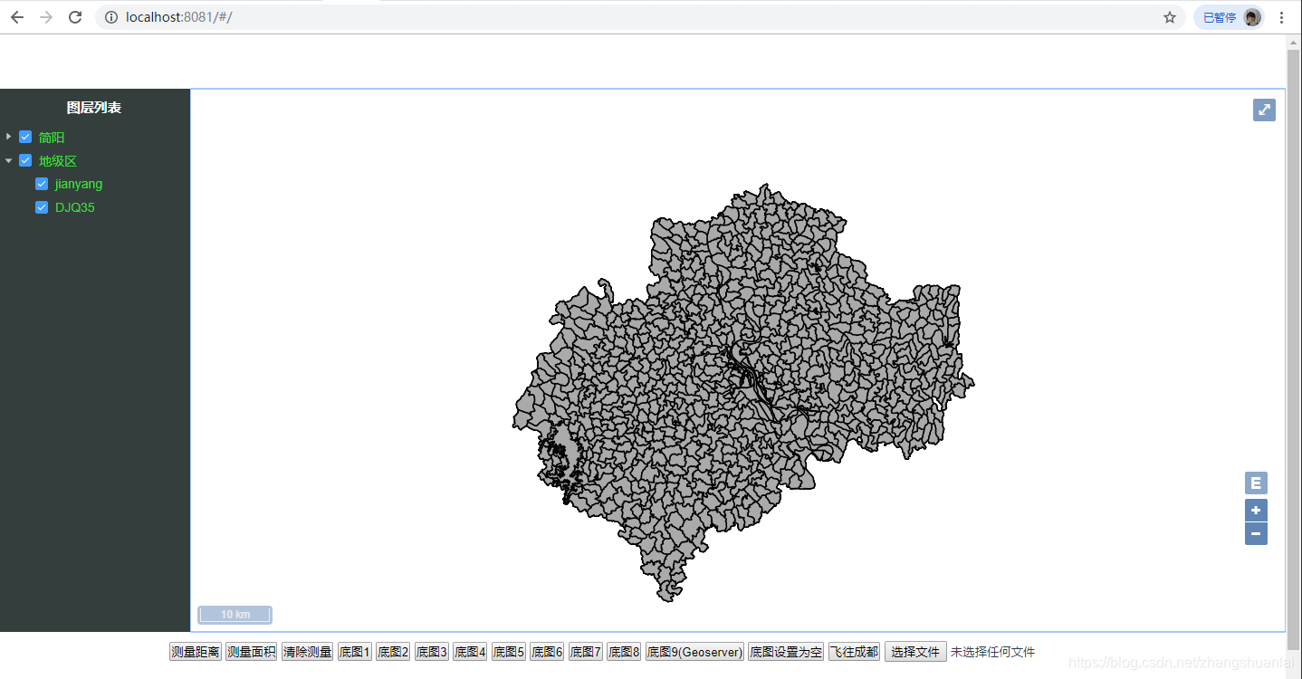
1.地图界面
2.vue结构
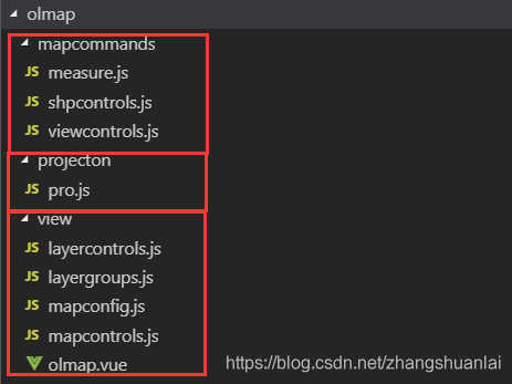
3.view文件夹
3.1olmap.vue
<template>
<div>
<!-- <div id="map" ref="rootmap" class="map"></div> -->
<div id="fullscreen" class="fullscreen">
<div tabindex="1" id="map" ref="rootmap" class="map"></div>
<div class="sidepanel">
<span class="sidepanel-title">图层列表</span>
<el-tree
:data="tree"
show-checkbox
node-key="id"
ref="tree"
:default-expanded-keys="[0]"
:default-checked-keys="[0,1]"
:props="defaultProps"
@check="click"
@node-click="handleNodeClick"
></el-tree>
<div id="layerControl" class="layerControl">
<ul id="layerTree" class="layerTree"></ul>
</div>
</div>
</div>
<button @click="selected('length')">测量距离</button>
<button @click="selected('area')">测量面积</button>
<button @click="removemeasure()">清除测量</button>
<button @click="fun(1)">底图1</button>
<button @click="fun(2)">底图2</button>
<button @click="fun(3)">底图3</button>
<button @click="fun(4)">底图4</button>
<button @click="fun(5)">底图5</button>
<button @click="fun(6)">底图6</button>
<button @click="fun(7)">底图7</button>
<button @click="fun(8)">底图8</button>
<button @click="fun(9)">底图9(Geoserver)</button>
<button @click="fun(0)">底图设置为空</button>
<button @click="flyTo()">飞往成都</button>
<input id="files" type="file" accept=".shp" @change="addshp()" ref="fileInput" />
<!-- <button @click="addshp()">添加shp到地图中</button> -->
<div id="mouseposition" ref="xyposition" :style="{marginTop:'100px'}"></div>
</div>
</template>
<script>
import "ol/ol.css";
import { Map, View } from "ol";
import {
Group as LayerGroup,
Vector as VectorLayer,
Tile as TileLayer
} from "ol/layer.js";
import {
XYZ,
BingMaps,
OSM,
TileArcGISRest,
Vector as VectorSource
} from "ol/source.js";
import TileWMS from "ol/source/TileWMS.js";
import mapcontrols from "./mapcontrols.js";
import layercontrols from "./layercontrols.js";
import mapconfig from "./mapconfig";
import measure from "../mapcommands/measure.js";
import viewcontrols from "../mapcommands/viewcontrols.js";
import projection from "../projecton/pro.js";
import TileGrid from "ol/tilegrid/TileGrid";
import { GPX, GeoJSON, IGC, KML, TopoJSON } from "ol/format.js";
import {
defaults as defaultInteractions,
DragAndDrop,
PinchZoom
} from "ol/interaction.js";
import { fromLonLat } from "ol/proj.js";
import Projection from "ol/proj/Projection.js";
import { register } from "ol/proj/proj4.js";
import proj4 from "proj4";
import shpcontrols from "../mapcommands/shpcontrols.js";
import { open } from "shapefile";
import layergroups from "./layergroups.js";
export default {
data() {
return {
map: null,
tree: null,
defaultProps: {
children: "children",
label: "label"
}
};
},
mounted() {
let self = this;
var mapcontainer = this.$refs.rootmap;
var mapxyposition = this.$refs.xyposition;
self.source = new VectorSource({ wrapX: true });
var dragAndDropInteraction = new DragAndDrop({
formatConstructors: [GPX, GeoJSON, IGC, KML, TopoJSON]
});
dragAndDropInteraction.on("addfeatures", function(event, mymap) {
var vectorSource = new VectorSource({
features: event.features
});
self.map.addLayer(
new VectorLayer({
renderMode: "image",
source: vectorSource,
projection: projection.projection
})
);
self.map.getView().fit(vectorSource.getExtent());
});
this.layer = new TileLayer();
this.view = mapconfig.view;
var mylayergroups = layergroups.layergroups;
this.map = new Map({
controls: mapcontrols,
target: mapcontainer,
interactions: defaultInteractions({
constrainResolution: true,
onFocusOnly: true
}).extend([
dragAndDropInteraction,
new PinchZoom({
constrainResolution: true
})
]),
layers: [this.layer, mylayergroups, measure.vector(self.source)],
view: this.view
});
this.tree=layercontrols.loadLayersControl(this.map);
},
methods: {
fun(num) {
this.layer.setSource(mapconfig.basemapsource(num));
},
removemeasure() {
measure.removemeasuretip(this);
this.selected("None");
},
selected(shp) {
this.map.removeInteraction(this.draw);
if (shp != "None") {
measure.addInteraction(this, shp);
}
},
flyTo() {
viewcontrols.flyTo([35371814, 3430209], this.view);
},
addshp() {
let self = this;
var file = this.$refs.fileInput.files[0];
shpcontrols.addshape(self, file);
},
click(checkedKeys, checkedNodes) {
layercontrols.treeControl(checkedKeys, checkedNodes,this.map)
},
}
};
</script>
<style map>
.fullscreen:-moz-full-screen {
height: 100%;
}
.fullscreen:-webkit-full-screen {
height: 100%;
}
.fullscreen:-ms-fullscreen {
height: 100%;
}
.fullscreen:fullscreen {
height: 100%;
}
.fullscreen {
margin-bottom: 10px;
width: 100%;
height: 600px;
}
.ol-rotate {
top: 3em;
}
.sidepanel {
background: rgb(52, 63, 61);
width: 15%;
height: 100%;
float: right;
}
.map {
width: 85%;
height: 100%;
float: right;
}
.sidepanel-title {
width: 100%;
color: #ffffff;
display: block;
font-weight: bold;
font-size: 15px;
margin-top: 10px;
margin-bottom: 10px;
text-align: center;
}
.tooltip {
position: relative;
background: rgba(0, 0, 0, 0.5);
border-radius: 4px;
color: white;
padding: 4px 8px;
opacity: 0.7;
white-space: nowrap;
}
.tooltip-measure {
opacity: 1;
font-weight: bold;
}
.tooltip-static {
background-color: #ffcc33;
color: black;
border: 1px solid white;
}
.tooltip-measure:before,
.tooltip-static:before {
border-top: 6px solid rgba(0, 0, 0, 0.5);
border-right: 6px solid transparent;
border-left: 6px solid transparent;
content: "";
position: absolute;
bottom: -6px;
margin-left: -7px;
left: 50%;
}
.tooltip-static:before {
border-top-color: #ffcc33;
}
.ol-mouse-position {
position: absolute;
top: 95%;
font-size: 0.8em;
background: #ffffff;
opacity: 0.7;
}
.ol-zoom {
position: absolute;
top: 75%;
opacity: 0.9;
left: 96%;
}
.ol-zoom-extent {
position: absolute;
top: 70%;
opacity: 0.9;
left: 96%;
}
.layerControl {
font-size: 13px;
color: #ffffff;
}
.layerTree li {
list-style: none;
margin: 10px;
text-align: left;
}
.el-tree{
color: #3adf35;
background: rgb(52, 63, 61)
}
</style>
3.2mapconfig.js
import TileGrid from "ol/tilegrid/TileGrid";
import { fromLonLat } from "ol/proj.js";
import { View } from "ol";
import {
XYZ,
BingMaps,
OSM,
TileArcGISRest,
TileWMS,
Vector as VectorSource
} from "ol/source.js";
import projection from "../projecton/pro.js";
var zeroFill = function(num, len, radix) {
var str = num.toString(radix || 10);
while (str.length < len) {
str = "0" + str;
}
return str;
};
var origin = [2.98768e7, 1.00021e7];
var fullExtent = [
29876800.0,
1874083.7439674865,
38004816.25603251,
10002100.0
];
var resolutions = [
10583.354500042335,
2645.8386250105837,
264.5838625010584,
132.2919312505292,
66.1459656252646,
33.0729828126323,
16.933367200067735,
8.466683600033868,
4.233341800016934,
2.116670900008467,
1.0583354500042335
];
var tileGrid = new TileGrid({
tileSize: 256,
origin: origin,
extent: fullExtent,
resolutions: resolutions
});
var basemapsource = function(mapsource) {
var basemapsource = null;
switch (mapsource) {
case 0:
basemapsource = null;
break;
case 1:
basemapsource = new OSM();
break;
case 2:
basemapsource = new TileArcGISRest({
url: "https://map.geoq.cn/ArcGIS/rest/services/ChinaOnlineCommunity/MapServer"
});
break;
case 3:
basemapsource = new BingMaps({
imagerySet: "Aerial",
key: "As1HiMj1PvLPlqc_gtM7AqZfBL8ZL3VrjaS3zIb22Uvb9WKhuJObROC-qUpa81U5"
});
break;
case 4:
basemapsource = new XYZ({
tileGrid: tileGrid,
projection: projection.projection,
tileUrlFunction: function(coordinate) {
var x = "C" + zeroFill(coordinate[1], 8, 16);
var y = "R" + zeroFill(-coordinate[2] - 1, 8, 16);
var z = "L" + zeroFill(coordinate[0], 2, 10);
return "/static/_alllayers/" + z + "/" + y + "/" + x + ".png";
}
});
break;
case 5:
basemapsource = new XYZ({
url: "https://t0.tianditu.gov.cn/DataServer?T=vec_w&x={x}&y={y}&l={z}&tk=01648a46241de4244d518d8e151b3528"
});
break;
case 6:
basemapsource = new XYZ({
url: "https://t0.tianditu.gov.cn/DataServer?T=img_w&x={x}&y={y}&l={z}&tk=01648a46241de4244d518d8e151b3528"
});
break;
case 7:
basemapsource = new XYZ({
url: "https://t0.tianditu.gov.cn/DataServer?T=ter_w&x={x}&y={y}&l={z}&tk=01648a46241de4244d518d8e151b3528"
});
break;
case 8:
basemapsource = new XYZ({
url: "https://t0.tianditu.gov.cn/DataServer?T=cva_w&x={x}&y={y}&l={z}&tk=01648a46241de4244d518d8e151b3528"
});
break;
case 9:
basemapsource = new TileWMS({
url: 'http://127.0.0.1:8080/geoserver/zsl/wms',
params: {
'TILED': true,
'FORMAT': 'image/png',
'VERSION': '1.1.0',
'LAYERS': 'zsl:jianyang',
"exceptions": 'application/vnd.ogc.se_inimage',
}
});
break;
}
return basemapsource;
};
var view = new View({
projection: projection.projection,
center: fromLonLat([104.0716, 30.66799], projection.projection),
zoom: 5
});
var mapconfig = {
tileGrid: tileGrid,
basemapsource: basemapsource,
view: view
};
export
default mapconfig;
3.3mapcontrols.js
import { createStringXY } from "ol/coordinate.js";
import {
Attribution,
defaults as defaultControls,
Control,
FullScreen,
MousePosition,
OverviewMap,
ScaleLine,
Zoom,
ZoomSlider,
ZoomToExtent,
LayerSwitcher,
} from "ol/control.js";
var mapcontrols = defaultControls().extend([
new FullScreen({
source: "fullscreen"
}),
new ScaleLine({
source: "scaleline"
}),
new MousePosition({
source: "mouseposition",
coordinateFormat: createStringXY(4),
}),
new ZoomToExtent({
extent: [
29876800.0,
1874083.7439674865,
38004816.25603251,
10002100.0
]
}),
new Zoom({
source: "zoom"
}),
]);
export default mapcontrols;
3.4layercontrols.js
var loadLayersControl = function(map) {
var layergroup = new Array();
var layergroupName = new Array();
var layer = new Array();
var layerName = new Array();
var group = new Array();
var layergrouptree = new Array();
var layergroups = map.getLayers().item(1).getLayers();
for (var i = layergroups.getLength() - 1; i >= 0; i--) {
layergroup[i] = layergroups.item(i);
layergroupName[i] = layergroup[i].get("name");
group = layergroup[i].getLayers();
console.log(layergroupName[i]);
var father = {
id: i,
label: layergroupName[i],
children: []
};
for (var j = group.getLength() - 1; j >= 0; j--) {
layer[j] = group.item(j);
console.log(layer[j]);
layerName[j] = layer[j].get("name");
console.log(layerName[j]);
father.children.push({
id: i + "-" + j,
label: layerName[j]
});
}
layergrouptree.push(father);
}
return layergrouptree;
};
var getTreeCheck = function(Keys, Key) {
if (Keys.indexOf(Key) != -1) {
return true;
} else {
return false;
}
};
var setLayerVisible = function(layerid, ischecked, map) {
var layer = new Array();
var group = new Array();
var layergroups = map.getLayers().item(1).getLayers();
for (var i = layergroups.getLength() - 1; i >= 0; i--) {
group = layergroups.item(i).getLayers();
for (var j = group.getLength() - 1; j >= 0; j--) {
layer[j] = group.item(j);
var grouplayerid = layer[j].get("id");
console.log(layer[j].get("id"));
if (grouplayerid == layerid) {
if (ischecked == true) {
layer[j].setVisible(true);
} else {
layer[j].setVisible(false);
}
}
}
}
};
var treeControl = function(checkedKeys, checkedNodes, map) {
if (checkedKeys.children) {
for (var i = 0; i < checkedKeys.children.length; i++) {
var trr = this.getTreeCheck(checkedNodes.checkedKeys, checkedKeys.children[i].id);
this.setLayerVisible(checkedKeys.children[i].id, trr, map);
}
} else {
var trr = this.getTreeCheck(checkedNodes.checkedKeys, checkedKeys.id);
this.setLayerVisible(checkedKeys.id, trr, map);
console.log(trr);
}
};
var layercontrols = {
loadLayersControl: loadLayersControl,
getTreeCheck: getTreeCheck,
setLayerVisible: setLayerVisible,
treeControl: treeControl,
};
export default layercontrols;
3.5layergroups.js
import { Group as LayerGroup, Tile as TileLayer } from 'ol/layer.js';
import {
TileWMS,
} from "ol/source.js";
var geolayer = function(Workspace, layername, layerid) {
var geolayer = new TileLayer({
source: new TileWMS({
url: "http://127.0.0.1:8080/geoserver/" + Workspace + "/wms",
params: {
TILED: true,
FORMAT: "image/png",
VERSION: "1.1.0",
LAYERS: Workspace + ":" + layername,
exceptions: "application/vnd.ogc.se_inimage"
}
}),
id: layerid,
name: layername,
});
return geolayer;
}
var layergroups = new LayerGroup({
layers: [
new LayerGroup({
layers: [
geolayer("zsl", "DJQ35", "0-0"),
geolayer("zsl", "jianyang", "0-1"),
],
name: "地级区",
}),
new LayerGroup({
layers: [
geolayer("zsl", "DJQ35", "1-0"),
geolayer("zsl", "DJZQ35", "1-1"),
],
name: "简阳",
}),
],
name: "layergroups01",
});
var layergroups = {
geolayer: geolayer,
layergroups: layergroups,
};
export default layergroups;
4.projecton文件夹
4.1pro.js
import Projection from "ol/proj/Projection.js";
import { register } from "ol/proj/proj4.js";
import proj4 from "proj4";
proj4.defs(
"EPSG:4523",
"+proj=tmerc +lat_0=0 +lon_0=105 +k=1 +x_0=35500000 +y_0=0 +ellps=GRS80 +units=m +no_defs"
);
register(proj4);
const projection = new Projection({
code: "EPSG:4523",
extent: [35345643.07, 2489940.65, 35623868.1, 4676052.19]
});
var pro = {
projection: projection,
};
export default pro;
5.mapcommands文件夹
5.1viewcontrols.js
import { fromLonLat } from 'ol/proj.js';
import { easeIn, easeOut } from 'ol/easing.js'
var flyTo = function(location, view) {
var duration = 2000;
var zoom = view.getZoom();
var parts = 2;
var called = false;
function callback(complete) {
--parts;
if (called) {
return;
}
if (parts === 0 || !complete) {
called = true;
}
}
view.animate({
center: location,
duration: duration
}, callback);
view.animate({
zoom: zoom - 1,
duration: duration / 2
}, {
zoom: zoom,
duration: duration / 2
}, callback);
}
var viewcontrols = {
flyTo: flyTo,
};
export default viewcontrols;
5.2measure.js
import { Vector as VectorLayer } from "ol/layer.js";
import { Vector as VectorSource } from "ol/source.js";
import { Draw } from "ol/interaction.js";
import { Circle as CircleStyle, Fill, Stroke, Style } from "ol/style.js";
import Overlay from "ol/Overlay.js";
import { getArea, getLength } from "ol/sphere.js";
import { LineString, Polygon } from "ol/geom.js";
var vector = function(source) {
var vector = new VectorLayer({
source: source,
style: new Style({
fill: new Fill({
color: "rgba(255, 255, 255, 0.2)"
}),
stroke: new Stroke({
color: "#ffcc33",
width: 2
}),
image: new CircleStyle({
radius: 7,
fill: new Fill({
color: "#ffcc33"
})
})
})
});
return vector;
};
var addInteraction = function(self, typevalue) {
var type = typevalue == "area" ? "Polygon" : "LineString";
self.draw = new Draw({
source: self.source,
type: type,
style: new Style({
fill: new Fill({
color: "rgba(255, 255, 255, 0.2)"
}),
stroke: new Stroke({
color: "rgba(0, 0, 0, 0.5)",
lineDash: [10, 10],
width: 2
}),
image: new CircleStyle({
radius: 5,
stroke: new Stroke({
color: "rgba(0, 0, 0, 0.7)"
}),
fill: new Fill({
color: "rgba(255, 255, 255, 0.2)"
})
})
})
});
self.map.addInteraction(self.draw);
createMeasureTooltip(self);
var listener;
self.draw.on(
"drawstart",
function(evt) {
self.sketch = evt.feature;
var tooltipCoord = evt.coordinate;
listener = self.sketch.getGeometry().on("change", function(evt) {
var geom = evt.target;
var output;
if (geom instanceof Polygon) {
output = formatArea(geom);
tooltipCoord = geom.getInteriorPoint().getCoordinates();
} else if (geom instanceof LineString) {
output = formatLength(geom);
tooltipCoord = geom.getLastCoordinate();
}
self.measureTooltipElement.innerHTML = output;
self.measureTooltip.setPosition(tooltipCoord);
});
},
self
);
self.draw.on(
"drawend",
function() {
console.log(self.measureTooltipElement);
self.measureTooltipElement.className = "tooltip tooltip-static";
self.measureTooltip.setOffset([0, -7]);
self.sketch = null;
self.measureTooltipElement = null;
createMeasureTooltip(self);
},
self
);
};
var createMeasureTooltip = function(self) {
if (self.measureTooltipElement == undefined) {
self.measureTooltipElement = document.createElement("div");
self.measureTooltipElement.className = "tooltip tooltip-measure";
self.measureTooltip = new Overlay({
element: self.measureTooltipElement,
offset: [0, -15],
positioning: "bottom-center"
});
self.map.addOverlay(self.measureTooltip);
} else {
if (self.measureTooltipElement) {
self.measureTooltipElement.parentNode.removeChild(
self.measureTooltipElement
);
}
self.measureTooltipElement = document.createElement("div");
self.measureTooltipElement.className = "tooltip tooltip-measure";
self.measureTooltip = new Overlay({
element: self.measureTooltipElement,
offset: [0, -15],
positioning: "bottom-center"
});
self.map.addOverlay(self.measureTooltip);
}
};
var formatLength = function(line) {
var length = getLength(line);
var output;
if (length > 100) {
output = Math.round((length / 1000) * 100) / 100 + " " + "km";
} else {
output = Math.round(length * 100) / 100 + " " + "m";
}
return output;
};
var formatArea = function(polygon) {
var area = getArea(polygon);
var output;
if (area > 10000) {
output = Math.round((area / 1000000) * 100) / 100 + " " + "km<sup>2</sup>";
} else {
output = Math.round(area * 100) / 100 + " " + "m<sup>2</sup>";
}
return output;
};
var removemeasuretip = function(self) {
self.source.clear();
self.map.getOverlays().clear();
};
var measure = {
vector: vector,
addInteraction: addInteraction,
createMeasureTooltip: createMeasureTooltip,
formatLength: formatLength,
formatArea: formatArea,
removemeasuretip: removemeasuretip
};
export default measure;
5.3shpcontrols.js
import { open } from "shapefile";
import { Vector as VectorLayer } from "ol/layer.js";
import { Vector as VectorSource } from "ol/source.js";
import { GeoJSON } from "ol/format.js";
import layercontrols from "../view/layercontrols.js";
var addshape = function(self, file) {
var name = file.name;
var index = name.lastIndexOf(".");
var filename = name.substr(0, index);
console.log(file);
var reader = new FileReader();
reader.readAsArrayBuffer(file);
var geojsonObject = {
type: "FeatureCollection",
features: []
};
reader.onload = function() {
open(this.result).then(source =>
source.read().then(function log(result) {
if (result.done) {
console.log(geojsonObject);
var vectorLayer = new VectorLayer({
source: new VectorSource({
features: new GeoJSON().readFeatures(geojsonObject)
}),
name: filename
});
self.map.addLayer(vectorLayer);
layercontrols.loadLayersControl(self.map, "layerTree");
return;
}
geojsonObject.features.push(result.value);
return source.read().then(log);
})
);
};
};
var shpcontrols = {
addshape: addshape
};
export default shpcontrols;
6.package.json
{
    "name": "vueols",
    "version": "1.0.0",
    "description": "A Vue.js project",
    "author": "zsl",
    "private": true,
    "scripts": {
        "dev": "webpack-dev-server --inline --progress --config build/webpack.dev.conf.js",
        "start": "npm run dev",
        "unit": "jest --config test/unit/jest.conf.js --coverage",
        "e2e": "node test/e2e/runner.js",
        "test": "npm run unit && npm run e2e",
        "build": "node build/build.js"
    },
    "dependencies": {
        "@types/proj4": "^2.5.0",
        "element-ui": "^2.10.1",
        "ol": "^5.3.3",
        "pbf": "^3.2.0",
        "proj4": "^2.5.0",
        "shapefile": "^0.6.6",
        "vue": "^2.5.2",
        "vue-router": "^3.0.1"
    },
    "devDependencies": {
        "autoprefixer": "^7.1.2",
        "babel-core": "^6.22.1",
        "babel-helper-vue-jsx-merge-props": "^2.0.3",
        "babel-jest": "^21.0.2",
        "babel-loader": "^7.1.1",
        "babel-plugin-dynamic-import-node": "^1.2.0",
        "babel-plugin-syntax-jsx": "^6.18.0",
        "babel-plugin-transform-es2015-modules-commonjs": "^6.26.0",
        "babel-plugin-transform-runtime": "^6.22.0",
        "babel-plugin-transform-vue-jsx": "^3.5.0",
        "babel-preset-env": "^1.3.2",
        "babel-preset-stage-2": "^6.22.0",
        "babel-register": "^6.22.0",
        "chalk": "^2.0.1",
        "chromedriver": "^2.27.2",
        "copy-webpack-plugin": "^4.0.1",
        "cross-spawn": "^5.0.1",
        "css-loader": "^0.28.0",
        "extract-text-webpack-plugin": "^3.0.0",
        "file-loader": "^1.1.4",
        "friendly-errors-webpack-plugin": "^1.6.1",
        "html-webpack-plugin": "^2.30.1",
        "jest": "^22.0.4",
        "jest-serializer-vue": "^0.3.0",
        "nightwatch": "^0.9.12",
        "node-notifier": "^5.1.2",
        "optimize-css-assets-webpack-plugin": "^3.2.0",
        "ora": "^1.2.0",
        "portfinder": "^1.0.13",
        "postcss-import": "^11.0.0",
        "postcss-loader": "^2.0.8",
        "postcss-url": "^7.2.1",
        "rimraf": "^2.6.0",
        "selenium-server": "^3.0.1",
        "semver": "^5.3.0",
        "shelljs": "^0.7.6",
        "uglifyjs-webpack-plugin": "^1.1.1",
        "url-loader": "^0.5.8",
        "vue-jest": "^1.0.2",
        "vue-loader": "^13.3.0",
        "vue-style-loader": "^3.0.1",
        "vue-template-compiler": "^2.5.2",
        "webpack": "^3.6.0",
        "webpack-bundle-analyzer": "^2.9.0",
        "webpack-dev-server": "^2.9.1",
        "webpack-merge": "^4.1.0"
    },
    "engines": {
        "node": ">= 6.0.0",
        "npm": ">= 3.0.0"
    },
    "browserslist": [
        "> 1%",
        "last 2 versions",
        "not ie <= 8"
    ]
}


 该博客主要介绍了一个基于Vue的项目结构,重点围绕地图界面展开。详细阐述了view、projecton、mapcommands等文件夹下的文件,如olmap.vue、mapconfig.js等,还提及了package.json,展示了项目的整体架构。


 332
332

 被折叠的 条评论
为什么被折叠?
被折叠的 条评论
为什么被折叠?
 到【灌水乐园】发言


