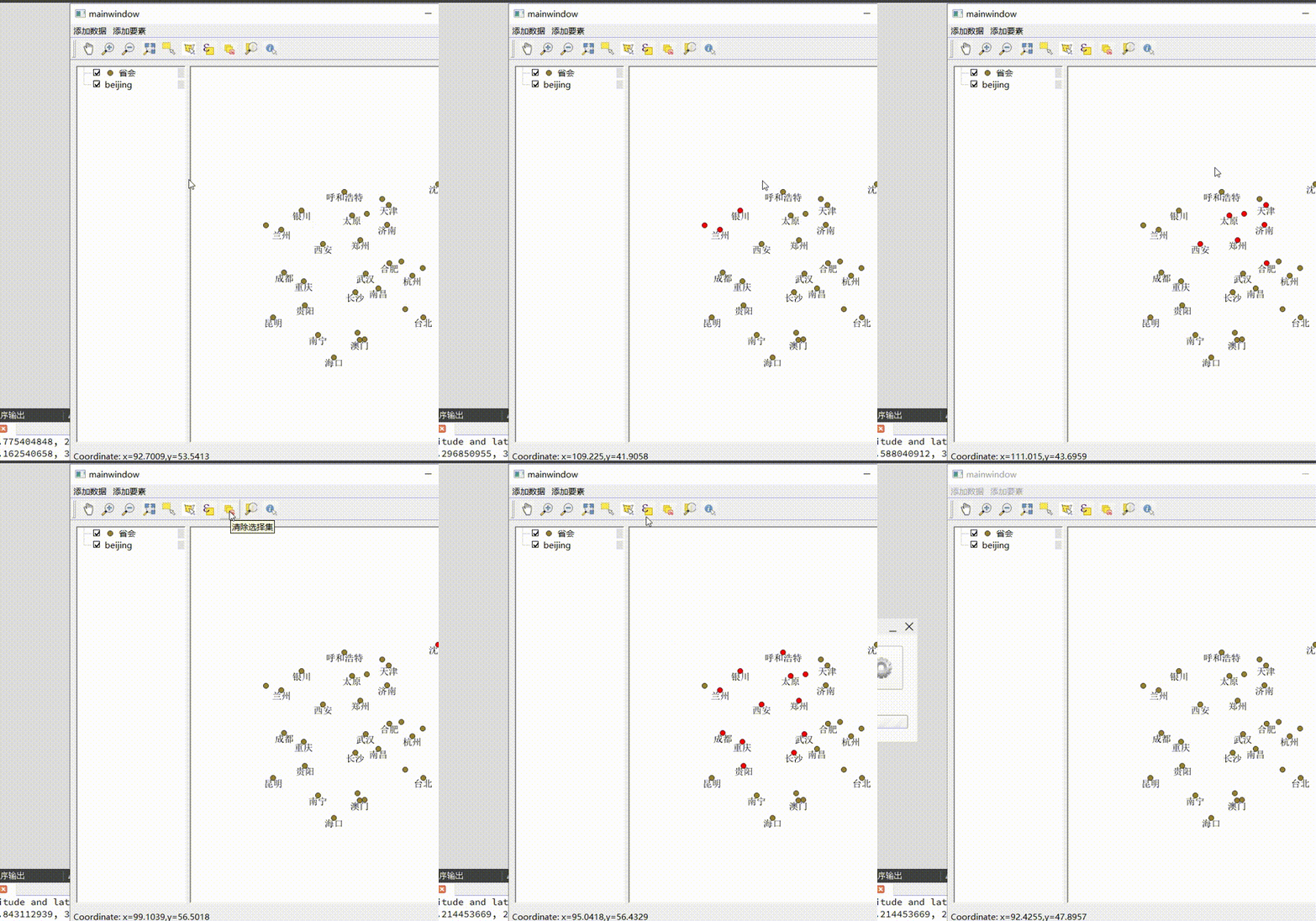
效果图,拉框选择要素,高亮显示。
1.代码块
需要创建一个类,类名为QgsMapToolSelectFeatures
1.1QgsMapToolSelectFeatures.h文件代码
#ifndef QGSMAPTOOLSELECTFEATURES_H
#define QGSMAPTOOLSELECTFEATURES_H

#endif // QGSMAPTOOLSELECTFEATURES_H
#include <QObject>
#include <QList>
#include <QScopedPointer>
#include<qmath.h>
#include <qgsmapcanvas.h>
#include <qgsmaptoolidentify.h>
#include <qgsrubberband.h>
#include <qgsmapmouseevent.h>
class QgsMapToolSelectFeatures : public QgsMapToolIdentify
{
    Q_OBJECT
public:
    QgsMapToolSelectFeatures(QgsMapCanvas *mapCanvas);
protected:
    //重写鼠标移动
    void canvasMoveEvent(QgsMapMouseEvent *e) override;
    //重写鼠标按下
    void canvasPressEvent(QgsMapMouseEvent *e) override;
    //重写鼠标抬起
    void canvasReleaseEvent(QgsMapMouseEvent *e) override;

    void initRubberBand();
    void identifyFromGeometry();
signals:
    //发出选中的要素信号
    void sigSelectFeatureChange(QList<QgsFeature>);
private:
    // 是否正在选择
    bool mSelectionActive = false;
    QScopedPointer<QgsRubberBand> mSelectionRubberBand;
    QColor mFillColor = QColor(254, 178, 76, 63);
    QColor mStrokeColor = QColor(254, 58, 29, 100);
    QPoint mInitDragPos;
    //选择的Geometry
    QgsGeometry mSelectGeometry;
};
2.1QgsMapToolSelectFeatures .cpp文件代码
#include "QgsMapToolSelectFeatures.h"
#include"QgsMapToolIdentify.h"
#include "qgsapplication.h"
#include "qgsvectorlayer.h"
#include<QMessageBox>
#include<QMessageBox>
#include<qgsfeature.h>
#include<qgsvectorlayer.h>
#include<qgsrectangle.h>
#include<QMouseEvent>
#include<QMessageBox>


QgsMapToolSelectFeatures::QgsMapToolSelectFeatures(QgsMapCanvas *mapCanvas)
    : QgsMapToolIdentify(mapCanvas)
{

}
void QgsMapToolSelectFeatures::canvasMoveEvent(QgsMapMouseEvent * e)
{
    if (e->buttons() != Qt::LeftButton)
        return;
    QRect rect;
    if (!mSelectionActive)
    {
        mSelectionActive = true;
        rect = QRect(e->pos(), e->pos());
    }
    else
    {
        rect = QRect(e->pos(), mInitDragPos);
    }
    if (mSelectionRubberBand)
        mSelectionRubberBand->setToCanvasRectangle(rect);
}

void QgsMapToolSelectFeatures::canvasPressEvent(QgsMapMouseEvent * e)
{
    if (!mSelectionRubberBand)
        initRubberBand();
    mInitDragPos = e->pos();
}

void QgsMapToolSelectFeatures::canvasReleaseEvent(QgsMapMouseEvent * e)
{
    QPoint point = e->pos() - mInitDragPos;
    //点
    if (!mSelectionActive || (point.manhattanLength() < QApplication::startDragDistance()))
    {
        mSelectionActive = false;
        mSelectGeometry = QgsGeometry::fromPointXY(toMapCoordinates(e->pos()));
        identifyFromGeometry();
    }
    //矩形
    if (mSelectionRubberBand && mSelectionActive)
    {
        mSelectGeometry = mSelectionRubberBand->asGeometry();
        mSelectionRubberBand.reset();
        identifyFromGeometry();

//        QgsVectorLayer *vlayer=qobject_cast<QgsVectorLayer*>(mCanvas->currentLayer());
//        //searchfeature
//            QgsFeature f;//selectfeature
//            QgsFeatureRequest fReq;
//            QRect rect;
//            rect = QRect(e->pos(), e->pos());
//            const QgsMapToPixel*mtransform=mCanvas->getCoordinateTransform();
//            QgsPointXY lb=mtransform->toMapCoordinates(rect.left(),rect.bottom());
//            QgsPointXY rt=mtransform->toMapCoordinates(rect.right(),rect.top());
//            QgsRectangle rectSearch(lb,rt);
//            fReq.setFilterRect(rectSearch);
//            fReq.setFlags(QgsFeatureRequest::ExactIntersect);
//            QgsAttributeList subsetList;
//            subsetList<<0<<2<<8;
//            fReq.setSubsetOfAttributes(subsetList);
//            QgsFeatureIterator fit=vlayer->getFeatures(fReq);
//            fit.rewind();
//            QgsFeatureIds lst;
//            QString info;
//            while(fit.nextFeature(f)==true)
//            {
//                const QgsFields pFields=f.fields();
//                for(int i=0;i<pFields.size();++i){
//                    QVariant att=f.attribute(i);
//                    QString strAtt=att.toString();
//                    qDebug()<<"Feild["<<i<<"]="<<pFields.at(i).name()<<endl;
//                    qDebug()<<"Attribute["<<i<<"]="<<strAtt<<endl;
//                    info+=pFields.at(i).name()+"\t"+strAtt+"\n";
//                }
//           lst<<f.id();
//           }
//           //select

//          QMessageBox msg;
//          msg.setText(info);
//          msg.exec();

    }
    mSelectionActive = false;


}

void QgsMapToolSelectFeatures::initRubberBand()
{
    mSelectionRubberBand.reset(new QgsRubberBand(mCanvas, QgsWkbTypes::PolygonGeometry));
    mSelectionRubberBand->setFillColor(mFillColor);
    mSelectionRubberBand->setStrokeColor(mStrokeColor);
}
void QgsMapToolSelectFeatures::identifyFromGeometry()
{
    if (mCanvas)
    {
        mCanvas->setSelectionColor(Qt::red);//设置颜色
        QList< QgsMapLayer * > 	layers = mCanvas->layers();
        foreach (QgsMapLayer *l , layers)
        {
            QgsVectorLayer *l1 = qobject_cast<QgsVectorLayer*>(l);
            l1->removeSelection();
        }
    }
    //返回选中的结果
    QList<IdentifyResult> results = QgsMapToolIdentify::identify(mSelectGeometry, IdentifyMode::TopDownAll, AllLayers);
    //选择的Features集合
    QList<QgsFeature> selectFeatures;
    //显示出来
    for (int i = 0; i < results.count(); ++i)
    {
        QgsVectorLayer *layer = qobject_cast<QgsVectorLayer*>(results.at(i).mLayer);
        QgsFeatureIds ids;
        for (IdentifyResult var : results)
        {
            QgsFeature _Feature = var.mFeature;
            ids.insert(_Feature.id());
        }
        if (ids.count() > 0)
            layer->selectByIds(ids);
        QgsFeature feature = results.at(i).mFeature;
        selectFeatures.append(feature);
    }
     //发出选中的Feature信息信号
        if (selectFeatures.count() > 0)
            emit sigSelectFeatureChange(selectFeatures);
}
1.3mainwindow.cpp文件代码
#include "qgsmaptoolidentifyfeature.h"
#include "QgsMapToolSelectFeatures.h"
//若还有其他头文件可以视情况加
void MainWindow::on_action_triggered()
{

    //QgsMapToolselectFeature实例化
    QgsMapToolSelectFeatures* m_mapidentifyfeature = new QgsMapToolSelectFeatures(m_mapcanvas);
    m_mapcanvas->setMapTool(m_mapidentifyfeature);//将工具添加到m_mapcanvas上
}


 958
958

 被折叠的 条评论
为什么被折叠?


