组件代码
<template>
<div>
<div>
<span>Geometry type </span>
<select v-model="typeSelected"
@change="getTypeSelected">
<option value="Point">点</option>
<option value="LineString">线</option>
<option value="Polygon">多边形</option>
<option value="Circle">圆</option>
<option value="None">无</option>
</select>
<button @click="getAllFeatures">获取添加的元素</button>
</div>
<div id="map"
ref="rootmap"></div>
</div>
</template>
<script>
import "ol/ol.css";
import { Map, View } from "ol";
import { Vector as LayerVec, Image } from 'ol/layer'
import { Vector as SourceVec, ImageWMS } from "ol/source";
import { Style, Stroke } from "ol/style";
import Draw from "ol/interaction/Draw";
import Projection from 'ol/proj/Projection'
export default {
data () {
return {
typeSelected: 'Point',
map: null,
vectorBox: null,
drawLayer: null,
draw: null
};
},
mounted () {
let that = this
let mapUrl = "http://111.229.215.211:8080/geoserver/sxmap/wms"
let mapName = "sxmap:hfshape"
let myCode = "EPSG:404000"
let myUnits = 'degrees'
let extent = [-5783.940779486906, 2420.684125662136, -3999.448596040022, 5088.623484956386]
let wmsLayer = [
new Image({
source: new ImageWMS({
ratio: 1,
url: mapUrl,
params: {
'FORMAT': 'image/png',
'VERSION': '1.1.1',
"STYLES": '',
"LAYERS": mapName,
"exceptions": 'application/vnd.ogc.se_inimage',
}
})
})
];
let projection = new Projection({
code: myCode,
units: myUnits,
global: false
})
that.map = new Map({
layers: wmsLayer,
target: 'map',
view: new View({
projection,
zoom: 4,
maxZoom: 20,
}),
});
that.map.getView().fit(extent, that.map.getSize());
that.map.on('singleclick', function (e) {
console.log("coordinate", e.coordinate)
})
let vectorBox = new SourceVec({
features: []
})
that.vectorBox = vectorBox
let drawLayer = new LayerVec({
source: vectorBox
})
that.drawLayer = drawLayer
that.map.addLayer(drawLayer)
this.addDraw()
},
methods: {
getTypeSelected () {
this.draw && this.map.removeInteraction(this.draw);
this.addDraw();
},
addDraw () {
let value = this.typeSelected;
if (value !== 'None') {
this.draw = new Draw({
source: this.drawLayer.getSource(),
type: this.typeSelected,
style: new Style({
stroke: new Stroke({
color: 'blue',
width: 3
})
})
});
this.map.addInteraction(this.draw);
}
},
getAllFeatures () {
let that = this
let Features = that.vectorBox.getFeatures()
console.log('Features', Features)
if (Features && Features.length) {
console.log(Features[0].getGeometry().flatCoordinates)
}
}
}
};
</script>
<style lang="less" scoped>
#map {
height: 500px;
}
.ol-attribution,
.ol-zoom {
display: none;
}
</style>
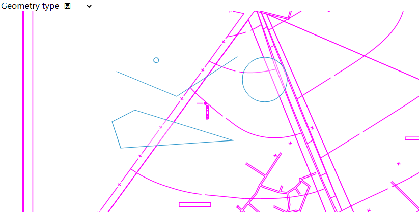
效果图
参考文档
参考文档01
参考文档02


 该博客详细介绍了如何使用OpenLayers库在Web应用中创建地图,并实现地图上的几何对象绘制(点、线、多边形、圆)及交互功能,包括选择类型、获取添加的元素等操作。通过示例代码展示了地图初始化、图层添加、单击事件监听以及绘制工具的添加和管理。


 204
204

 被折叠的 条评论
为什么被折叠?
被折叠的 条评论
为什么被折叠?
 到【灌水乐园】发言


