


1、建表,同时建索引
SRID 取 0,代表平面坐标系。
create table spatial_point_in_line (
	`id` int unsigned not null auto_increment primary key ,
	`min` int unsigned not null default 0,
	`max` int unsigned not null default 0,
	`line_geo` geometry  not null srid 0,
	SPATIAL INDEX index_spatial_line_geo(`line_geo`)
)
2、插入数据
insert into spatial_point_in_line (min, max, line_geo)
values
-- (80, 90,  ST_GeomFromText(CONCAT('LINESTRING(', min, ' 0,', max, ' 0)'), 0)),
-- (80, 100, ST_GeomFromText(CONCAT('LINESTRING(', min, ' 0,', max, ' 0)'), 0)),
-- (90, 100, ST_GeomFromText(CONCAT('LINESTRING(', min, ' 0,', max, ' 0)'), 0)),
-- (100, 110, ST_GeomFromText(CONCAT('LINESTRING(', min, ' 0,', max, ' 0)'), 0)),
-- (100, 120, ST_GeomFromText(CONCAT('LINESTRING(', min, ' 0,', max, ' 0)'), 0))
(80, 90,  LineString(Point(min, 0), Point(max, 0))),
(80, 100, LineString(Point(min, 0), Point(max, 0))),
(90, 100, LineString(Point(min, 0), Point(max, 0))),
(100, 110, LineString(Point(min, 0), Point(max, 0))),
(100, 120, LineString(Point(min, 0), Point(max, 0)))
3、点在线上,不在两端
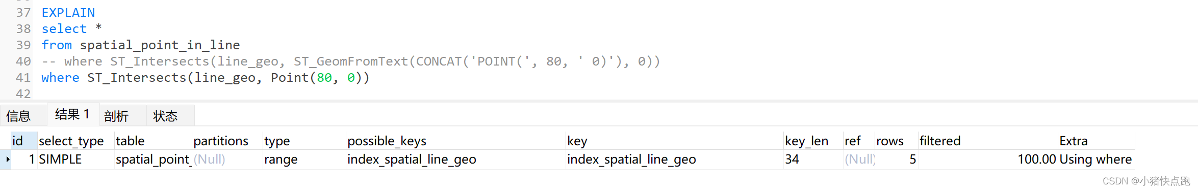
ST_Contains 同 MBRContains,其他类似。
EXPLAIN
select *
from spatial_point_in_line
-- where ST_Contains(line_geo, ST_GeomFromText(CONCAT('POINT(', 81, ' 0)'), 0))
where ST_Contains(line_geo, Point(81, 0))

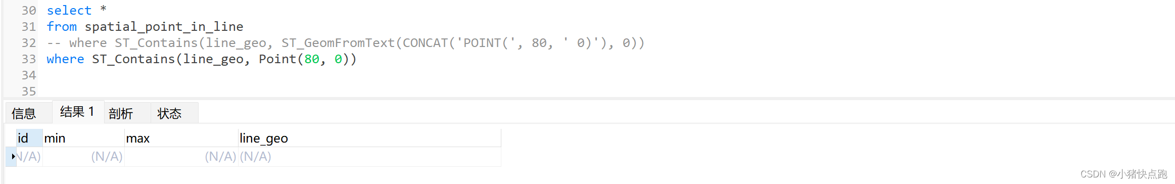
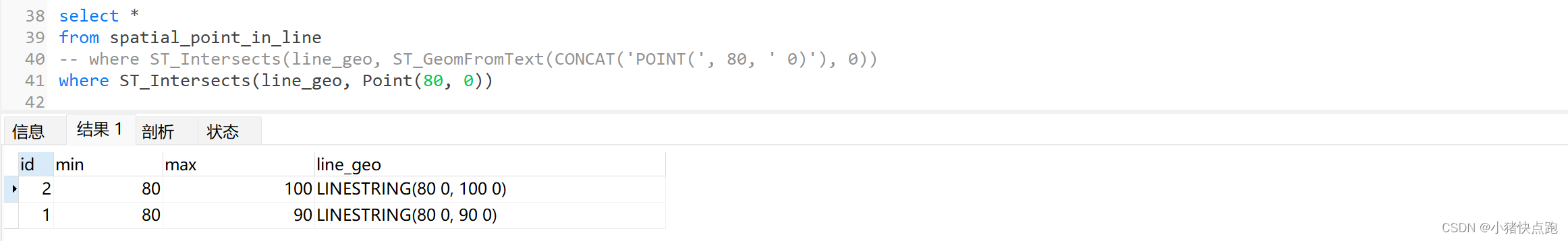
4、点在线上,可在两端
EXPLAIN
select *
from spatial_point_in_line
-- where ST_Intersects(line_geo, ST_GeomFromText(CONCAT('POINT(', 80, ' 0)'), 0))
where ST_Intersects(line_geo, Point(80, 0))


 被折叠的 条评论
为什么被折叠?
被折叠的 条评论
为什么被折叠?
 到【灌水乐园】发言


