


 这篇内容涉及NOAA的气候数据记录,具体是AVHRR叶面积指数(LAI)和吸收光合有效辐射部分(FAPAR)的第四版数据集。数据集每日以0.05°分辨率提供,覆盖全球陆地,但不包括特定区域。已知问题包括时间、纬度和经度的准确性误差。数据集可用于植被覆盖和光合作用研究,且提供了质量控制标志。代码示例展示了如何在特定日期范围内使用该数据集。
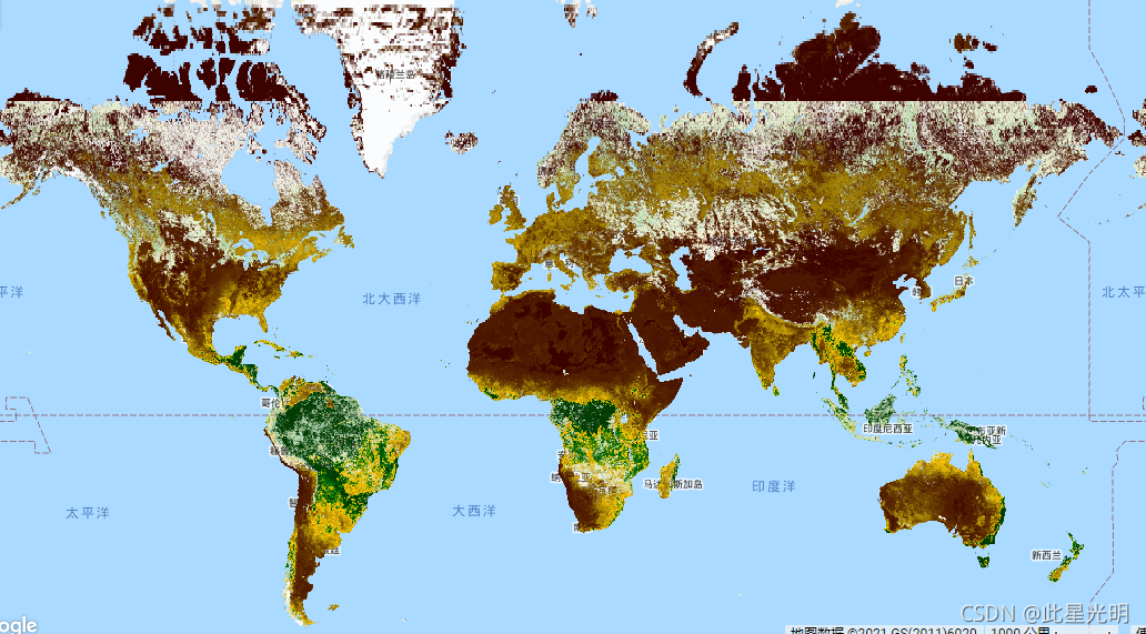
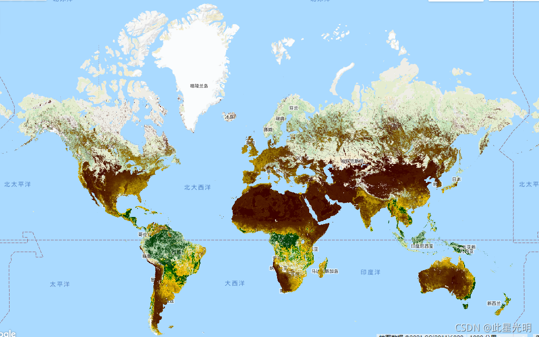
The NOAA Climate Data Record (CDR) of AVHRR Leaf Area Index (LAI) and Fraction of Absorbed Photosynthetically Active Radiation (FAPAR) dataset contains derived values that characterize the canopy and photosynthetic activity of plants. This dataset is derived from the NOAA AVHRR Surface Reflectance product and is gridded at a resolution of 0.05° on a daily basis. The values are computed globally over land surfaces, but not over bare or very sparsely vegetated areas, permanent ice or snow, permanent wetland, urban areas, or water bodies.
Known issues with this dataset include:
-
TIMEOFDAY variable contains values that are too large by 1 day
-
Latitude values are not correctly associated with the center of the grid cell, error is < 0.002 degrees
-
Longitude values are not correctly associated with the center of the grid cell, error is < 0.02 degrees
See technical note from the data provider.
NOAA气候数据记录(CDR)的AVHRR叶面积指数(LAI)和吸收光合有效辐射的部分(FAPAR)数据集包含描述植物冠层和光合活动的衍生值。该数据集来自NOAA AVHRR表面反射产品,并以0.05°的分辨率按日进行网格化。这些数值是在全球范围内计算的,但不包括光秃秃的或植被非常稀少的地区、永久的冰或雪、永久的湿地、城市地区或水体。
这个数据集的已知问题包括。
TIMEOFDAY变量所包含的数值过大,超过1天。
纬度值与网格单元的中心没有正确关联,误差<0.002度
经度值与网格单元的中心没有正确关联,误差< 0.02度
见数据提供者的技术说明。
Resolution
5566 meters
Bands Table
| Name | Description | Min* | Max* | Scale |
|---|---|---|---|---|
| LAI | Leaf area index | 0 | 6205 | 0.001 |
| FAPAR | Fraction of absorbed photosynthetic active radiation | 0 | 896 | 0.001 |
| QA | Quality control bit flags | 0 | ||
| QA Bitmask |
| |||
* = Values are estimated
CLOSEIMPORT
影像属性:
| Name | Type | Description |
|---|---|---|
| status | String | 'provisional' or 'permanent' |
引用:
The NOAA CDR Program’s official distribution point for CDRs is NOAA’s National Climatic Data Center which provides sustained, open access and active data management of the CDR packages and related information in keeping with the United States’ open data policies and practices as described in the President's Memorandum on "Open Data Policy" and pursuant to the Executive Order of May 9, 2013, "Making Open and Machine Readable the New Default for Government Information". In line with these policies, the CDR data sets are nonproprietary, publicly available, and no restrictions are placed upon their use. For more information, see the Fair Use of NOAA's CDR Data Sets, Algorithms and Documentation pdf.
Martin Claverie, Eric Vermote, and NOAA CDR Program (2014): NOAA Climate Data Record (CDR) of Leaf Area Index (LAI) and Fraction of Absorbed Photosynthetically Active Radiation (FAPAR), Version 4. [indicate subset used]. NOAA National Climatic Data Center. doi:10.7289/V5M043BX
代码:
var dataset = ee.ImageCollection('NOAA/CDR/AVHRR/LAI_FAPAR/V4')
                  .filter(ee.Filter.date('2018-02-01', '2018-03-01'));
var leafAreaIndex = dataset.select('LAI');
var leafAreaIndexVis = {
  min: 0.0,
  max: 4000.0,
  palette: ['3b0200', '977705', 'ca9f06', 'ffca09', '006a03', '003b02'],
};
Map.setCenter(20, 24.5, 2);
Map.addLayer(leafAreaIndex, leafAreaIndexVis, 'Leaf Area Index');
代码:
var dataset = ee.ImageCollection('NOAA/CDR/AVHRR/LAI_FAPAR/V5')
                  .filter(ee.Filter.date('2018-02-01', '2018-03-01'));
var leafAreaIndex = dataset.select('LAI');
var leafAreaIndexVis = {
  min: 0.0,
  max: 4000.0,
  palette: ['3b0200', '977705', 'ca9f06', 'ffca09', '006a03', '003b02'],
};
Map.setCenter(20, 24.5, 2);
Map.addLayer(leafAreaIndex, leafAreaIndexVis, 'Leaf Area Index');


 2986
2986

 被折叠的 条评论
为什么被折叠?
被折叠的 条评论
为什么被折叠?
 到【灌水乐园】发言


