


 本文详细介绍使用SuperMap iServer和Visual Studio 2015等工具,通过C#编程实现最佳路径分析的过程。从构建二维网格数据集开始,经过线拓扑处理,最终在SuperMap iServer中进行最佳路径检测。文章提供了完整的代码示例,涵盖图层参数设置、站点选择、路径提交及结果展示等关键步骤。
开发工具与关键技术:SuperMap iDesktop9D、iServer、Visual Studio 2015、Sql、.Net、C#
撰写时间:2019年01月19日
最佳路径分析:选点提交分析最佳路径功能,以下为功能完成图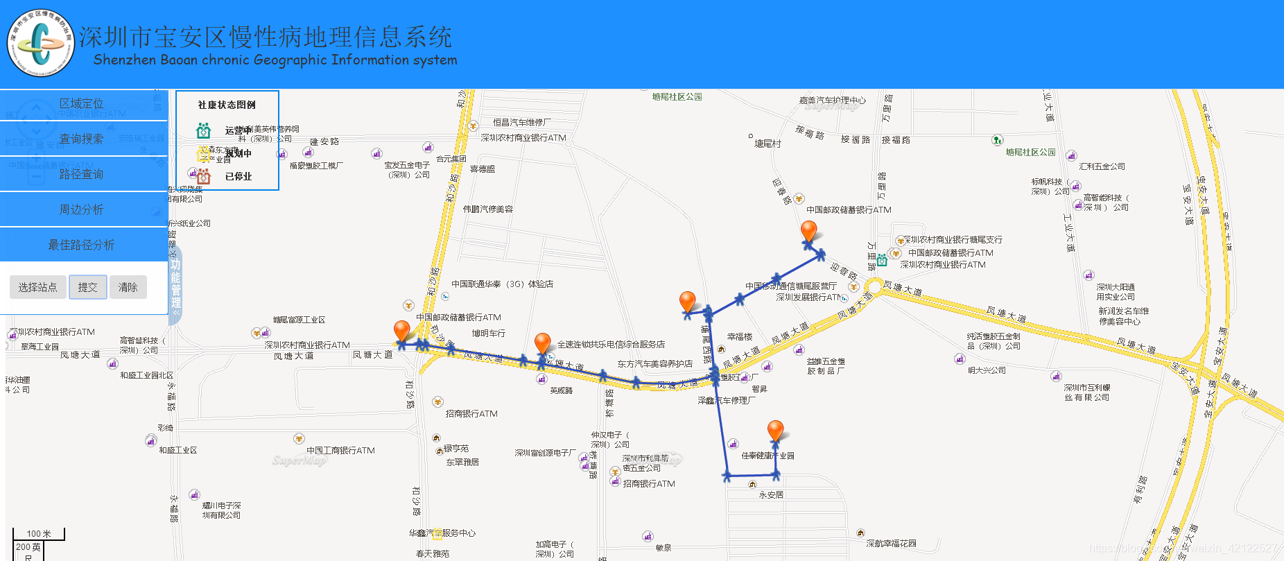
先到SuperMap iDesktop 9D 此数据源里构建二位网格选择所有线数据,再选择此二位网格数据进行线拓扑处理,处理完成之后就可以进行检测,点击此创建处理好的二维网格点击SuperMap iDesktop 9D里的空间分析下的最佳路径进行检测,选择站点后运行路线显示即成功。
见实现的代码:
先声明图层参数、图层样式用于图层显示,在这里的连接和后面提交方法的权重名称可以到iServer的服务列表下的交通网络分析里进行复制
//街道网格
        var url2 = "http://localhost:8090/iserver/services/transportationAnalyst-BADistrictWorkingSpace/rest/networkanalyst/Xianlu@ShenZhenBaoAn_Data";
        var drawPoint, vctorLayer, markerLayers, select, nodeArray = [], pathTime, pathListIndex = 0, routeCompsIndex = 0,
        style = {
            strokeColor: "#304DBE",
            strokeWidth: 3,
            pointerEvents: "visiblePainted",
            fill: false
        },
        styleGuidePoint = {
            pointRadius: 10,
            externalGraphic: "/ContentTGM/Maps/images/walk.png"
        },
        styleGuideLine = {
            strokeColor: "#25FF25",
            strokeWidth: 6,
            fill: false
        };
        vectorLayer = new SuperMap.Layer.Vector("路线", {displayInLayerSwitcher:false});
        drawPoint = new SuperMap.Control.DrawFeature(vectorLayer, SuperMap.Handler.Point);
        select = new SuperMap.Control.SelectFeature(vectorLayer, { onSelect: onFeatureSelects, onUnselect: onFeatureUnselects });
        drawPoint.events.on({ "featureadded": drawCompleted });
        markerLayers = new SuperMap.Layer.Markers("站点",{displayInLayerSwitcher:false});
记得把图层的参数填进添加图层方法里,接下来具体方法:
选择站点:
 //选择站点
        function selectPoints() {
            clearElements();
            drawPoint.activate();
        }
        //接收站点的信息并添加站点的icon样式
        function drawCompleted(drawGeometryArgs) {
            var point = drawGeometryArgs.feature.geometry,
            size = new SuperMap.Size(44, 33),
            offset = new SuperMap.Pixel(-(size.w / 2), -size.h),
            icon = new SuperMap.Icon("/SuperMap/theme/images/marker.png", size, offset);
            markerLayers.addMarker(new SuperMap.Marker(new SuperMap.LonLat(point.x, point.y), icon));
            nodeArray.push(point);
        }
        //选中时显示路径指引信息
        function onFeatureSelects(feature) {
            if (feature.attributes.description) {
                popup = new SuperMap.Popup("chicken",
                feature.geometry.getBounds().getCenterLonLat(),
                new SuperMap.Size(200, 30),
                "<div style='font-size:.8em; opacity: 0.8'>" + feature.attributes.description + "</div>",
                null, false);
                feature.popup = popup;
                map.addPopup(popup);
            }
            if (feature.geometry.CLASS_NAME != "SuperMap.Geometry.Point") {
                feature.style = styleGuideLine;
                vectorLayer.redraw();
            }
        }
        //清除要素时调用此函数
        function onFeatureUnselects(feature) {
            map.removePopup(feature.popup);
            feature.popup.destroy();
            feature.popup = null;
            if (feature.geometry.CLASS_NAME != "SuperMap.Geometry.Point") {
                feature.style = style;
            }
            vectorLayer.redraw();
        }
进行提交:
 //提交方法
       function findPath() {
           drawPoint.deactivate();
           var findPathService, parameter, analystParameter, resultSetting;
           resultSetting = new SuperMap.REST.TransportationAnalystResultSetting({
               returnEdgeFeatures: true,
               returnEdgeGeometry: true,
               returnEdgeIDs: true,
               returnNodeFeatures: true,
               returnNodeGeometry: true,
               returnNodeIDs: true,
               returnPathGuides: true,
               returnRoutes: true
           });
           analystParameter = new SuperMap.REST.TransportationAnalystParameter({
               resultSetting: resultSetting,
               weightFieldName: "SmLength"//这里是权重名称
           });
           parameter = new SuperMap.REST.FindPathParameters({
               isAnalyzeById: false,
               nodes: nodeArray,
               hasLeastEdgeCount: false,
               parameter: analystParameter
           });
           if (nodeArray.length <= 1) {
               alert("站点数目有误");
           }
           findPathService = new SuperMap.REST.FindPathService(url2, {
               eventListeners: { "processCompleted": processCompleted }
           });
           findPathService.processAsync(parameter);
       }
       function processCompleted(findPathEventArgs) {
           var result = findPathEventArgs.result;
           allScheme(result);
       }
       function allScheme(result) {
           if (pathListIndex < result.pathList.length) {
               addPath(result);
           } else {
               pathListIndex = 0;
               //线绘制完成后会绘制关于路径指引点的信息
               addPathGuideItems(result);
           }
       }
       //以动画效果显示分析结果
       function addPath(result) {
           if (routeCompsIndex < result.pathList[pathListIndex].route.components.length) {
               var pathFeature = new SuperMap.Feature.Vector();
               var points = [];
               for (var k = 0; k < 2; k++) {
                   if (result.pathList[pathListIndex].route.components[routeCompsIndex + k]) {
                       points.push(new SuperMap.Geometry.Point(result.pathList[pathListIndex].route.components[routeCompsIndex + k].x, result.pathList[pathListIndex].route.components[routeCompsIndex + k].y));
                   }
               }
               var curLine = new SuperMap.Geometry.LinearRing(points);
               pathFeature.geometry = curLine;
               pathFeature.style = style;
               vectorLayer.addFeatures(pathFeature);
               //每隔0.001毫秒加载一条弧段
               pathTime = setTimeout(function () { addPath(result); }, 0.001);
               routeCompsIndex++;
           } else {
               clearTimeout(pathTime);
               routeCompsIndex = 0;
               pathListIndex++;
               allScheme(result);
           }
       }
       function addPathGuideItems(result) {
           vectorLayer.removeAllFeatures();
           //显示每个pathGuideItem和对应的描述信息
           for (var k = 0; k < result.pathList.length; k++) {
               var pathGuideItems = result.pathList[pathListIndex].pathGuideItems, len = pathGuideItems.length;
               for (var m = 0; m < len; m++) {
                   var guideFeature = new SuperMap.Feature.Vector();
                   guideFeature.geometry = pathGuideItems[m].geometry;
                   guideFeature.attributes = { description: pathGuideItems[m].description };
                   if (guideFeature.geometry.CLASS_NAME === "SuperMap.Geometry.Point") {
                       guideFeature.style = styleGuidePoint;
                   }
                   else {
                       guideFeature.style = style;
                   }
                   vectorLayer.addFeatures(guideFeature);
               }
           }
           select.activate();
       }
       //清除
       function clearElements() {
           pathListIndex = 0;
           routeCompsIndex = 0;
           nodeArray = [];
           select.deactivate();
           if (vectorLayer.selectedFeatures.length > 0) {
               map.removePopup(vectorLayer.selectedFeatures[0].popup);
           }
           vectorLayer.removeAllFeatures();
           markerLayers.clearMarkers();
       }
在这里主要是在前面把二维网格数据集弄好,后面的就简单了,都可以在SuperMap iServer的for JavaScript示例里找到。


 被折叠的 条评论
为什么被折叠?
被折叠的 条评论
为什么被折叠?
 到【灌水乐园】发言


