


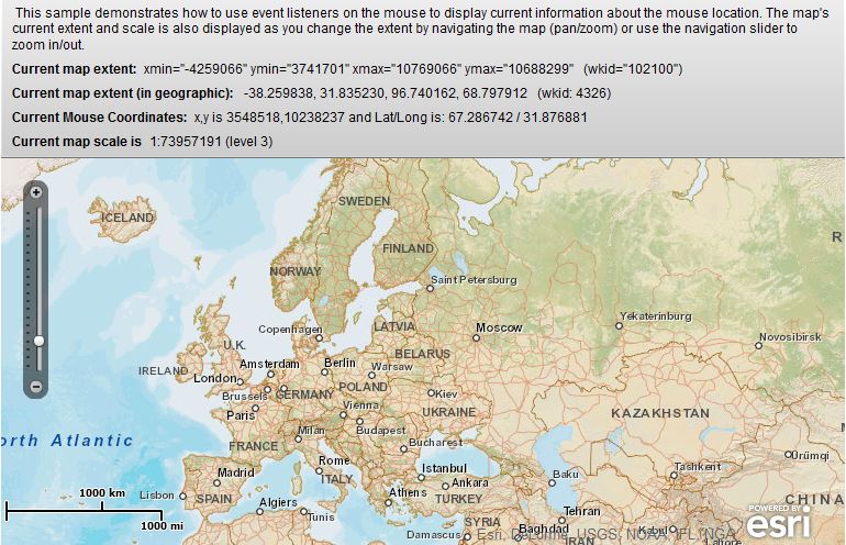
 本文介绍了一个使用Adobe Flex和Esri API实现的地图应用示例。该示例展示了如何实时显示鼠标在地图上的位置坐标及地理坐标,并更新地图当前范围和比例尺。
效果图如下:


 1 <?xml version="1.0" encoding="utf-8"?>
 2 <s:Application xmlns:fx="http://ns.adobe.com/mxml/2009"
 3                xmlns:s="library://ns.adobe.com/flex/spark"
 4                xmlns:esri="http://www.esri.com/2008/ags"
 5                pageTitle="Map Extent and Mouse Coordinates">
 6
 7     <fx:Script>
 8         <![CDATA[
 9             import com.esri.ags.geometry.Extent;
10             import com.esri.ags.geometry.MapPoint;
11             import com.esri.ags.utils.WebMercatorUtil;
12
13             // when mouse (cursor) is on the map ...
14             private function loadHandler():void
15             {
16                 myMap.addEventListener(MouseEvent.MOUSE_MOVE, mouseMoveHandler);
17             }
18
19             // ... show coordinates of current (mouse) location
20             private function mouseMoveHandler(event:MouseEvent):void
21             {
22                 const mapPoint:MapPoint = myMap.toMapFromStage(event.stageX, event.stageY);
23                 const latlong:MapPoint = WebMercatorUtil.webMercatorToGeographic(mapPoint) as MapPoint;
24                 mousecoords.text =
25                     "x,y is " + mapPoint.x.toFixed(0) + "," + mapPoint.y.toFixed(0)
26                     + " and Lat/Long is: " + latlong.y.toFixed(6)
27                     + " / " + latlong.x.toFixed(6);
28             }
29
30             // convert current projected extent to geographic and show as such
31             protected function showExtentInGeographic(extent:Extent):String
32             {
33                 const geoExtent:Extent = WebMercatorUtil.webMercatorToGeographic(myMap.extent) as Extent;
34                 // return geoExtent.toString() + ".." ;
35                 return " " + geoExtent.xmin.toFixed(6)
36                     + ", " + geoExtent.ymin.toFixed(6)
37                     + ", " + geoExtent.xmax.toFixed(6)
38                     + ", " + geoExtent.ymax.toFixed(6)
39                     + "   (wkid: " + geoExtent.spatialReference.wkid + ")";
40             }
41         ]]>
42     </fx:Script>
43
44     <s:controlBarLayout>
45         <s:VerticalLayout gap="10"
46                           paddingBottom="7"
47                           paddingLeft="10"
48                           paddingRight="10"
49                           paddingTop="7"/>
50     </s:controlBarLayout>
51     <s:controlBarContent>
52         <s:RichText width="100%">
53             This sample demonstrates how to use event listeners on the
54             mouse to display current information about the mouse location.
55             The map's current extent and scale is also displayed as you
56             change the extent by navigating the map (pan/zoom) or use the
57             navigation slider to zoom in/out.
58         </s:RichText>
59         <s:HGroup>
60             <s:Label fontWeight="bold" text="Current map extent:"/>
61             <s:RichEditableText editable="false" text='xmin="{myMap.extent.xmin.toFixed(0)}" ymin="{myMap.extent.ymin.toFixed(0)}" xmax="{myMap.extent.xmax.toFixed(0)}" ymax="{myMap.extent.ymax.toFixed(0)}"   (wkid="{myMap.spatialReference.wkid}")'/>
62         </s:HGroup>
63         <s:HGroup>
64             <s:Label fontWeight="bold" text="Current map extent (in geographic):"/>
65             <s:RichEditableText editable="false" text="{showExtentInGeographic(myMap.extent)}"/>
66         </s:HGroup>
67         <s:HGroup>
68             <s:Label fontWeight="bold" text="Current Mouse Coordinates:"/>
69             <s:RichEditableText id="mousecoords"
70                                 editable="false"
71                                 text="Move the mouse over the map to see its current coordinates..."/>
72         </s:HGroup>
73         <s:HGroup>
74             <s:Label fontWeight="bold" text="Current map scale is"/>
75             <s:RichEditableText editable="false" text="1:{myMap.scale.toFixed(0)} (level {myMap.level})"/>
76         </s:HGroup>
77     </s:controlBarContent>
78
79     <esri:Map id="myMap" load="loadHandler()">
80         <esri:extent>
81             <esri:Extent xmin="3035000" ymin="4305000" xmax="3475000" ymax="10125000">
82                 <esri:SpatialReference wkid="102100"/>
83                 <!-- same as tiled map service below -->
84             </esri:Extent>
85         </esri:extent>
86         <esri:ArcGISTiledMapServiceLayer url="http://server.arcgisonline.com/ArcGIS/rest/services/World_Street_Map/MapServer"/>
87     </esri:Map>
88
89 </s:Application>


 1万+
1万+

 被折叠的 条评论
为什么被折叠?
被折叠的 条评论
为什么被折叠?
 到【灌水乐园】发言


