


目录
具体如下:
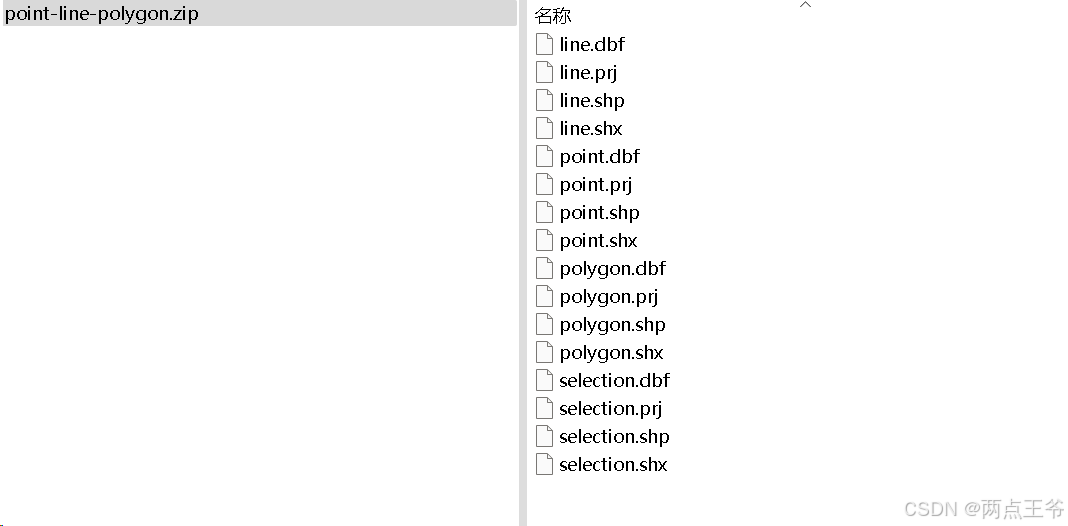
1、shp文件
SHP文件(Shapefile)是由**ESRI(Environmental Systems Research Institute)开发的一种常用的地理空间数据格式,用于存储矢量类型的地理信息数据。SHP文件通常用于GIS(地理信息系统)软件中,用来表示地理对象,如点、线、面等。
Shapefile 格式通常由至少三部分组成:
- .shp 文件:存储几何数据(如点、线、面)。
- .shx 文件:存储几何数据的索引。
- .dbf 文件:存储与几何数据相关的属性数据,采用表格格式。
其他可能的辅助文件包括:
- .prj:存储空间参考信息(坐标系等),投帧式,用于保存地理坐标系统与投影信息,是一个存储well-known text投影描述符的文本文件。
- .cpg:存储字符编码信息。
其他可选的文件:
- .sbnand.sbx— 几何体的空间索引
- .fbnand.fbx— 只读的Shapefiles的几何体的空间索引
- .ainand.aih— 列表中活动字段的属性索引。
- .ixs— 可读写Shapefile文件的地理编码索引
- .mxs— 可读写Shapefile文件的地理编码索引(ODB格式)
- .atx—.dbf文件的属性索引,其文件名格式为shapefile.columnname.atx(ArcGIS 8及之后的版本)
- .shp.xml— 以XML格式保存元数据。
SHP文件结构概述
- 几何数据:通常包括点(Point)、线(Line)、多边形(Polygon)等矢量数据。
- 属性数据:通过
.dbf文件与每个几何对象相关联,描述其属性(如名字、ID、面积等)。 - 索引数据:通过
.shx文件,便于快速定位几何数据的位置。
2、具体实现
实现方式有多种,选择2种做简要的说明
①使用GDAL实现
GDAL 提供了对矢量数据(如 Shapefile)的强大支持,包含读取、写入、转换等多种功能。使用GDAL实现的时候需要安装GDAL相关的软件包和JDK,也可以使用带GDAL的JDK,下面是:Java GIS 开发基础环境,带有GDAL的JDK1.8
https://download.youkuaiyun.com/download/qq_43544074/90203311![]() https://download.youkuaiyun.com/download/qq_43544074/90203311上面是整理过的,可以直接用,也可以在网上其他可下载的地方下载使用。
https://download.youkuaiyun.com/download/qq_43544074/90203311上面是整理过的,可以直接用,也可以在网上其他可下载的地方下载使用。
Download — GDAL documentation![]() https://gdal.org/en/stable/download.html有了基础环境,就可以具体实现解析了,如下:
https://gdal.org/en/stable/download.html有了基础环境,就可以具体实现解析了,如下:
添加依赖库
        <!--gdal-->
        <dependency>
            <groupId>org.gdal</groupId>
            <artifactId>gdal</artifactId>
            <version>3.5.0</version> <!--3.9.0、 3.2.0-->
        </dependency>
        <!--1-sqlite相关-->
        <!-- https://mvnrepository.com/artifact/org.xerial/sqlite-jdbc -->
        <dependency>
            <groupId>org.xerial</groupId>
            <artifactId>sqlite-jdbc</artifactId>
            <version>3.42.0.0</version>
        </dependency>
        <!--2-sqlite 方言-->
        <dependency>
            <groupId>com.zsoltfabok</groupId>
            <artifactId>sqlite-dialect</artifactId>
            <version>1.0</version>
        </dependency>

        <!-- 对数据库操作的统计 -->
        <dependency>
            <groupId>p6spy</groupId>
            <artifactId>p6spy</artifactId>
            <version>3.9.1</version>
        </dependency>
实现代码类
import org.gdal.gdal.gdal;
import org.gdal.ogr.*;

/**
 * gdalshapefile 读取器
 *
 * @author xjs
 * @date 2024/12/30
 */
public class GDALShapefileReader {

    public static void main(String[] args) {
        // 设置GDAL配置以支持UTF-8路径(包含中文等非ASCII字符)
        gdal.SetConfigOption("GDAL_FILENAME_IS_UTF8", "YES");

        // 调用读取Shapefile的封装方法
//        String shapefilePath = "D:\\app\\point\\point.shp";  // 修改为实际文件路径
//        String shapefilePath = "D:\\app\\line\\line.shp";  // 修改为实际文件路径
        String shapefilePath = "D:\\app\\polygon\\polygon.shp";  // 修改为实际文件路径
try {
            readShp(shapefilePath);
        } catch (Exception e) {
            e.printStackTrace();
        }
    }

    /**
     * 读取Shapefile的方法
     *
     * @param shapefilePath Shapefile文件路径
     * @throws Exception 异常
     */
    public static void readShp(String shapefilePath) throws Exception {
        // 初始化GDAL和OGR
        ogr.RegisterAll();

        // 获取驱动,ESRI Shapefile 驱动
        String strDriverName = "ESRI Shapefile";
        org.gdal.ogr.Driver oDriver = ogr.GetDriverByName(strDriverName);
        if (oDriver == null) {
            throw new Exception(strDriverName + " 驱动不可用!");
        }

        // 打开SHP文件(只读模式)
        DataSource dataSource = ogr.Open(shapefilePath, 0);  // 0表示只读模式
        if (dataSource == null) {
            throw new Exception("无法打开SHP文件!");
        }

        // 获取SHP文件中的第一个图层
        Layer layer = dataSource.GetLayer(0);  // 获取第一个图层
        int featureCount = (int) layer.GetFeatureCount();
        System.out.println("总共有 " + featureCount + " 个要素。");

        // 遍历每个Feature
        for (int i = 0; i < featureCount; i++) {
            // 获取单个Feature
            Feature feature = layer.GetFeature(i);

            // 打印Feature的ID
            System.out.println("\nFeature ID: " + feature.GetFID());

            // 获取几何数据(点、线、多边形等)
            Geometry geometry = feature.GetGeometryRef();
            if (geometry != null) {
                // 获取几何类型
                int geometryType = geometry.GetGeometryType();
                System.out.println("几何类型: " + geometryType);

                // 根据不同几何类型分别处理
                handleGeometryByType(geometry, geometryType);
            }

            // 遍历每个字段属性
            printFeatureFields(feature, layer);
        }

        // 清理资源
        dataSource.delete();
    }

    /**
     * 根据几何类型处理几何数据
     *
     * @param geometry     几何对象
     * @param geometryType 几何类型
     */
    private static void handleGeometryByType(Geometry geometry, int geometryType) {
        switch (geometryType) {
            case ogr.wkbPoint:  // 点类型
                System.out.println("这是一个点: " + geometry.ExportToWkt());
                break;

            case ogr.wkbLineString:  // 线类型
                System.out.println("这是一个线: " + geometry.ExportToWkt());
                break;

            case ogr.wkbPolygon:  // 面类型
                System.out.println("这是一个面: " + geometry.ExportToWkt());
                break;

            case ogr.wkbMultiPoint:  // 多点类型
                System.out.println("这是一个多点: " + geometry.ExportToWkt());
                break;

            case ogr.wkbMultiLineString:  // 多线类型
                System.out.println("这是一个多线: " + geometry.ExportToWkt());
                break;

            case ogr.wkbMultiPolygon:  // 多面类型
                System.out.println("这是一个多面: " + geometry.ExportToWkt());
                break;

            case ogr.wkbGeometryCollection:  // 几何集合类型
                System.out.println("这是一个几何集合: " + geometry.ExportToWkt());
                break;

            default:
                System.out.println("无法识别的几何类型: " + geometry.ExportToWkt());
        }
    }

    /**
     * 打印Feature的字段信息
     *
     * @param feature Feature对象
     * @param layer   Layer对象
     */
    private static void printFeatureFields(Feature feature, Layer layer) {
        // 遍历每个字段属性
        int fieldCount = feature.GetFieldCount();
        for (int j = 0; j < fieldCount; j++) {
            FieldDefn fieldDefn = layer.GetLayerDefn().GetFieldDefn(j);
            String fieldName = fieldDefn.GetNameRef();
            String fieldValue = feature.GetFieldAsString(j);
            System.out.println("字段: " + fieldName + " = " + fieldValue);
        }
    }
}
考虑保存到数据库中
import org.gdal.gdal.gdal;
import org.gdal.ogr.*;

import java.sql.Connection;
import java.sql.DriverManager;
import java.sql.SQLException;
import java.sql.Statement;

/**
 * gdalshapefile 读取器
 *
 * @author xjs
 * @date 2024/12/30
 */
public class GDALShapefileReaderToDb {

    public static void main(String[] args) {
        // 设置GDAL配置以支持UTF-8路径(包含中文等非ASCII字符)
        gdal.SetConfigOption("GDAL_FILENAME_IS_UTF8", "YES");

        // Shapefile路径和SQLite数据库路径
//        String shapefilePath = "D:\\app\\point\\point.shp";  // 修改为实际文件路径
//        String shapefilePath = "D:\\app\\line\\line.shp";  // 修改为实际文件路径
        String shapefilePath = "D:\\app\\polygon\\polygon.shp";  // 修改为实际文件路径
        String sqliteDbPath = "D:\\app\\shapefile_data.db";  // SQLite数据库路径

        try {
            // 创建SQLite数据库并插入Shapefile数据
            readShpAndInsertToSQLite(shapefilePath, sqliteDbPath);
        } catch (Exception e) {
            e.printStackTrace();
        }
    }

    /**
     * 读取Shapefile并将数据插入SQLite数据库
     *
     * @param shapefilePath Shapefile文件路径
     * @param sqliteDbPath  SQLite数据库文件路径
     * @throws Exception 异常
     */
    public static void readShpAndInsertToSQLite(String shapefilePath, String sqliteDbPath) throws Exception {
        // 初始化GDAL和OGR
        ogr.RegisterAll();

        // 获取驱动,ESRI Shapefile 驱动
        String strDriverName = "ESRI Shapefile";
        org.gdal.ogr.Driver oDriver = ogr.GetDriverByName(strDriverName);
        if (oDriver == null) {
            throw new Exception(strDriverName + " 驱动不可用!");
        }

        // 打开SHP文件(只读模式)
        DataSource dataSource = ogr.Open(shapefilePath, 0);  // 0表示只读模式
        if (dataSource == null) {
            throw new Exception("无法打开SHP文件!");
        }

        // 获取SHP文件中的第一个图层
        Layer layer = dataSource.GetLayer(0);  // 获取第一个图层
        int featureCount = (int) layer.GetFeatureCount();
        System.out.println("总共有 " + featureCount + " 个要素。");

        // 创建SQLite数据库连接
        Connection conn = DriverManager.getConnection("jdbc:sqlite:" + sqliteDbPath);
        Statement stmt = conn.createStatement();

        // 为不同的几何类型创建对应的表
        createTablesForGeometryTypes(stmt);

        // 遍历每个Feature并插入数据
        for (int i = 0; i < featureCount; i++) {
            Feature feature = layer.GetFeature(i);
            insertFeatureToSQLite(conn, stmt, feature, layer);
        }

        // 关闭数据库连接
        conn.close();

        // 清理资源
        dataSource.delete();
    }

    /**
     * 为不同几何类型创建SQLite表(Point, LineString, Polygon)
     *
     * @param stmt Statement对象
     * @throws SQLException 异常
     */
    private static void createTablesForGeometryTypes(Statement stmt) throws SQLException {
        // 创建Point表
        String createPointTableSQL = "CREATE TABLE IF NOT EXISTS point_data (id INTEGER PRIMARY KEY, geometry TEXT, attributes TEXT);";
        stmt.execute(createPointTableSQL);

        // 创建LineString表
        String createLineTableSQL = "CREATE TABLE IF NOT EXISTS line_data (id INTEGER PRIMARY KEY, geometry TEXT, attributes TEXT);";
        stmt.execute(createLineTableSQL);

        // 创建Polygon表
        String createPolygonTableSQL = "CREATE TABLE IF NOT EXISTS polygon_data (id INTEGER PRIMARY KEY, geometry TEXT, attributes TEXT);";
        stmt.execute(createPolygonTableSQL);
    }

    /**
     * 将Feature插入到SQLite数据库
     *
     * @param conn    数据库连接
     * @param stmt    Statement对象
     * @param feature Feature对象
     * @param layer   图层对象
     * @throws SQLException 异常
     */
    private static void insertFeatureToSQLite(Connection conn, Statement stmt, Feature feature, Layer layer) throws SQLException {
        // 获取字段数目和字段值
        int fieldCount = feature.GetFieldCount();
        StringBuilder insertSQL = new StringBuilder();

        // 获取几何类型并决定插入哪个表
        Geometry geometry = feature.GetGeometryRef();
        if (geometry == null) return;  // 如果没有几何数据,跳过

        int geometryType = geometry.GetGeometryType();
        String geometryWKT = geometry.ExportToWkt();  // 将几何数据转为WKT格式

        // 基于几何类型选择插入表
        switch (geometryType) {
            case ogr.wkbPoint:
                insertSQL.append("INSERT INTO point_data (geometry, attributes) VALUES ('")
                        .append(geometryWKT).append("', '").append(getAttributes(feature, layer))
                        .append("');");
                break;
            case ogr.wkbLineString:
                insertSQL.append("INSERT INTO line_data (geometry, attributes) VALUES ('")
                        .append(geometryWKT).append("', '").append(getAttributes(feature, layer))
                        .append("');");
                break;
            case ogr.wkbPolygon:
                insertSQL.append("INSERT INTO polygon_data (geometry, attributes) VALUES ('")
                        .append(geometryWKT).append("', '").append(getAttributes(feature, layer))
                        .append("');");
                break;
            default:
                // 如果是其他类型,可以选择忽略或者添加更多表
                System.out.println("不支持的几何类型,跳过该Feature。");
                return;
        }

        // 执行插入操作
        stmt.executeUpdate(insertSQL.toString());
    }

    /**
     * 获取Feature的属性字符串
     *
     * @param feature Feature对象
     * @param layer   图层对象
     * @return 属性的字符串表示
     */
    private static String getAttributes(Feature feature, Layer layer) {
        StringBuilder attributes = new StringBuilder();
        int fieldCount = feature.GetFieldCount();
        for (int i = 0; i < fieldCount; i++) {
            FieldDefn fieldDefn = layer.GetLayerDefn().GetFieldDefn(i);
            String fieldValue = feature.GetFieldAsString(i);
            attributes.append(fieldDefn.GetNameRef()).append(": ").append(fieldValue).append(", ");
        }
        // 删除最后一个逗号和空格
        if (attributes.length() > 2) {
            attributes.setLength(attributes.length() - 2);
        }
        return attributes.toString();
    }
}
添加一个其他的相关方法:
    /**
     * 获取图层信息
     * // 获取Layer信息 调用
     * getLayerInfo(layer);
     *
     * @throws Exception 例外
     */
    private static void getLayerInfo(Layer layer) throws Exception {
        // 图层名称
        String layerName = layer.GetName();
        System.out.println("图层名称:" + layerName);
        // 获取图层的空间参考
        SpatialReference spatialReference = layer.GetSpatialRef();
        System.out.println("空间参考坐标系:" + spatialReference.GetAttrValue("AUTHORITY", 0) + spatialReference.GetAttrValue("AUTHORITY", 1));
        // 图层范围
        double[] layerExtent = layer.GetExtent();
        System.out.println("layerExtent = " + Arrays.toString(layerExtent));
        System.out.println("图层范围:minx:" + layerExtent[0] + ",maxx:" + layerExtent[1] + ",miny:" + layerExtent[2] + ",maxy:" + layerExtent[3]);
    }

    /**
     * 坐标转换
     * // 转换坐标 调用
     * Geometry geometry = feature.GetGeometryRef();
     * coordinateTransform(geometry);
     */
    private static void coordinateTransform(Geometry geometry) throws Exception {
        // 创建目标空间参考 (EPSG:4326)
        SpatialReference targetSpatialRef = new SpatialReference();
        targetSpatialRef.ImportFromEPSG(4326); // EPSG:4326 是 WGS84
        // 获取图层的空间参考
        SpatialReference spatialReference = geometry.GetSpatialReference();
        System.out.println("空间参考坐标系:" + spatialReference.GetAttrValue("AUTHORITY", 0) + spatialReference.GetAttrValue("AUTHORITY", 1));
        // 创建坐标转换对象
        CoordinateTransformation coordTransform = CoordinateTransformation.CreateCoordinateTransformation(spatialReference, targetSpatialRef);

        double x = geometry.GetX();
        double y = geometry.GetY();

        // 创建包含 3 个元素的数组,Z 坐标可以设为 0
        double[] coords = new double[]{x, y, 0.0}; // Z 坐标默认值为 0
        coordTransform.TransformPoint(coords);
        System.out.println("转换后的坐标:" + Arrays.toString(coords));
    }
②使用geotools实现
官网:GeoTools The Open Source Java GIS Toolkit — GeoTools![]() https://geotools.org/添加对应的依赖
https://geotools.org/添加对应的依赖
<!-- 添加GeoTools依赖 <gt.version>20.0</gt.version> -->
<dependency>
<groupId>org.geotools</groupId>
<artifactId>gt-opengis</artifactId>
<version>${gt.version}</version>
</dependency>
<dependency>
<groupId>org.geotools</groupId>
<artifactId>gt-api</artifactId>
<version>${gt.version}</version>
</dependency>
<dependency>
<groupId>org.geotools</groupId>
<artifactId>gt-data</artifactId>
<version>${gt.version}</version>
</dependency>
<dependency>
<groupId>org.geotools</groupId>
<artifactId>gt-jdbc</artifactId>
<version>${gt.version}</version>
</dependency>
<dependency>
<groupId>org.geotools.jdbc</groupId>
<artifactId>gt-jdbc-postgis</artifactId>
<version>${gt.version}</version>
</dependency>
<dependency>
<groupId>org.geotools</groupId>
<artifactId>gt-main</artifactId>
<version>${gt.version}</version>
</dependency>
<dependency>
<groupId>org.geotools</groupId>
<artifactId>gt-metadata</artifactId>
<version>${gt.version}</version>
</dependency>
<dependency>
<groupId>org.geotools</groupId>
<artifactId>gt-referencing</artifactId>
<version>${gt.version}</version>
</dependency>
<dependency>
<groupId>org.geotools</groupId>
<artifactId>gt-render</artifactId>
<version>${gt.version}</version>
</dependency>
<dependency>
<groupId>org.geotools</groupId>
<artifactId>gt-shapefile</artifactId>
<version>${gt.version}</version>
</dependency>
<dependency>
<groupId>org.geotools</groupId>
<artifactId>gt-coverage</artifactId>
<version>${gt.version}</version>
</dependency>
<!-- 如果使用的 GeoTools 功能需要额外的依赖,如坐标转换,可能还需要添加这个 -->
<dependency>
<groupId>org.geotools</groupId>
<artifactId>gt-epsg-hsql</artifactId>
<version>${gt.version}</version>
</dependency>
<dependency>
<groupId>org.geotools</groupId>
<artifactId>gt-geojson</artifactId>
<version>${gt.version}</version>
</dependency>
<dependency>
<groupId>cn.hutool</groupId>
<artifactId>hutool-all</artifactId>
<version>5.7.15</version>
</dependency>
<!-- <!– wkt查询 –>-->
<!-- <dependency>-->
<!-- <groupId>com.vividsolutions</groupId>-->
<!-- <artifactId>jts-core</artifactId>-->
<!-- <version>1.14.0</version>-->
<!-- </dependency>-->
<!-- 1 栅格相关依赖 -->
<dependency>
<groupId>org.geotools</groupId>
<artifactId>gt-image</artifactId>
<version>${gt.version}</version>
</dependency>
<dependency>
<groupId>org.geotools</groupId>
<artifactId>gt-swing</artifactId>
<version>${gt.version}</version>
</dependency>
<dependency>
<groupId>org.geotools</groupId>
<artifactId>gt-process</artifactId>
<version>${gt.version}</version>
</dependency>
<dependency>
<groupId>org.geotools</groupId>
<artifactId>gt-process-raster</artifactId>
<version>${gt.version}</version>
</dependency>
<dependency>
<groupId>org.geotools</groupId>
<artifactId>gt-geotiff</artifactId>
<version>${gt.version}</version>
</dependency>
<!-- https://mvnrepository.com/artifact/org.geotools/gt-swing -->
<dependency>
<groupId>org.geotools</groupId>
<artifactId>gt-swing</artifactId>
<version>${gt.version}</version>
</dependency>
<!--<dependency>
<groupId>org.jdal</groupId>
<artifactId>jdal-core</artifactId>
<version>2.0.0</version>
</dependency>
-->
<dependency>
<groupId>org.apache.commons</groupId>
<artifactId>commons-imaging</artifactId>
<version>1.0-alpha3</version>
</dependency>
<!-- <dependency>
<groupId>org.geotools</groupId>
<artifactId>gt-netcdf</artifactId>
<version>20.0</version>
</dependency>-->
<!-- https://mvnrepository.com/artifact/edu.ucar/netcdf -->
<dependency>
<groupId>edu.ucar</groupId>
<artifactId>netcdf</artifactId>
<version>4.3.22</version>
</dependency>
<dependency>
<groupId>org.geotools</groupId>
<artifactId>gt-geometry</artifactId>
<version>20.0</version>
</dependency>
<!-- TwelveMonkeys ImageIO TIFF -->
<dependency>
<groupId>com.twelvemonkeys.imageio</groupId>
<artifactId>imageio-tiff</artifactId>
<version>3.8.0</version>
</dependency>
<!-- Maven example for JAI TIFF plugin -->
<dependency>
<groupId>javax.media</groupId>
<artifactId>jai-core</artifactId>
<version>1.1.3</version>
</dependency>
<!--gdal-->
<dependency>
<groupId>org.gdal</groupId>
<artifactId>gdal</artifactId>
<version>3.9.0</version>
</dependency>
<!-- https://mvnrepository.com/artifact/net.postgis/postgis-jdbc -->
<dependency>
<groupId>net.postgis</groupId>
<artifactId>postgis-jdbc</artifactId>
<version>2024.1.0</version>
</dependency>
<!--1-sqlite相关-->
<!-- https://mvnrepository.com/artifact/org.xerial/sqlite-jdbc -->
<dependency>
<groupId>org.xerial</groupId>
<artifactId>sqlite-jdbc</artifactId>
<version>3.42.0.0</version>
</dependency>
<!--2-sqlite 方言-->
<dependency>
<groupId>com.zsoltfabok</groupId>
<artifactId>sqlite-dialect</artifactId>
<version>1.0</version>
</dependency>
<!-- 对数据库操作的统计 -->
<dependency>
<groupId>p6spy</groupId>
<artifactId>p6spy</artifactId>
<version>3.9.1</version>
</dependency>
代码实现:
import org.geotools.data.DataStore;
import org.geotools.data.DataStoreFinder;
import org.geotools.data.shapefile.ShapefileDataStoreFactory;
import org.geotools.data.simple.SimpleFeatureIterator;
import org.geotools.data.simple.SimpleFeatureSource;
import org.locationtech.jts.geom.Geometry;
import org.locationtech.jts.geom.LineString;
import org.locationtech.jts.geom.Point;
import org.locationtech.jts.geom.Polygon;
import org.opengis.feature.simple.SimpleFeature;
import org.slf4j.Logger;
import org.slf4j.LoggerFactory;

import java.io.File;
import java.util.HashMap;
import java.util.Map;

public class ShapefileReader {

    private static final Logger logger = LoggerFactory.getLogger(ShapefileReader.class);

    public static void main(String[] args) {
        String shapefilePath = "D:\\app\\point\\point.shp";  // Shapefile 文件路径

//        String shapefilePath = "D:\\app\\line\\line.shp";  // 修改为实际文件路径
//        String shapefilePath = "D:\\app\\polygon\\polygon.shp";  // 修改为实际文件路径

            // Shapefile 文件路径
            File shapefile = new File(shapefilePath);

File shapefile = new File(shapefilePath);

        if (!shapefile.exists()) {
            logger.error("Shapefile 文件不存在: {}", shapefilePath);
            return;
        }

        DataStore dataStore = null;
        SimpleFeatureIterator featureIterator = null;
        try {
            // 创建数据存储对象
            dataStore = createDataStore(shapefile);

            if (dataStore == null) {
                logger.error("无法加载数据存储。");
                return;
            }

            // 获取 Shapefile 的第一个要素类型
            String typeName = dataStore.getTypeNames()[0];
            SimpleFeatureSource featureSource = dataStore.getFeatureSource(typeName);

            // 获取要素集合并遍历
            featureIterator = featureSource.getFeatures().features();
            while (featureIterator.hasNext()) {
                SimpleFeature feature = featureIterator.next();
                processFeature(feature);
            }

        } catch (Exception e) {
            logger.error("处理 Shapefile 时发生错误", e);
        } finally {
            // 清理资源
            closeResources(featureIterator, dataStore);
        }
    }

    /**
     * 创建 Shapefile 数据存储
     *
     * @param shapefile Shapefile 文件
     * @return DataStore 对象
     */
    private static DataStore createDataStore(File shapefile) {
        try {
            Map<String, Object> params = new HashMap<>();
            params.put(ShapefileDataStoreFactory.URLP.key, shapefile.toURI().toURL());
            return DataStoreFinder.getDataStore(params);
        } catch (Exception e) {
            logger.error("无法创建 DataStore", e);
        }
        return null;
    }

    /**
     * 处理每个 SimpleFeature 的几何类型
     *
     * @param feature SimpleFeature 对象
     */
    private static void processFeature(SimpleFeature feature) {
        Geometry geometry = (Geometry) feature.getDefaultGeometry();
        if (geometry != null) {
            if (geometry instanceof Point) {
                handlePoint((Point) geometry);
            } else if (geometry instanceof LineString) {
                handleLineString((LineString) geometry);
            } else if (geometry instanceof Polygon) {
                handlePolygon((Polygon) geometry);
            } else {
                logger.warn("未知几何类型: {}", geometry.getClass().getName());
            }
        }
    }

    /**
     * 处理点类型的几何对象
     *
     * @param point 点类型几何
     */
    private static void handlePoint(Point point) {
        logger.info("处理点类型: {}", point.getCoordinate());
    }

    /**
     * 处理线类型的几何对象
     *
     * @param line 线类型几何
     */
    private static void handleLineString(LineString line) {
        logger.info("处理线类型: {}", line.getCoordinates());
    }

    /**
     * 处理面类型的几何对象
     *
     * @param polygon 面类型几何
     */
    private static void handlePolygon(Polygon polygon) {
        logger.info("处理面类型: {}", polygon.getCoordinates());
    }

    /**
     * 清理资源
     *
     * @param featureIterator SimpleFeatureIterator
     * @param dataStore       DataStore
     */
    private static void closeResources(SimpleFeatureIterator featureIterator, DataStore dataStore) {
        try {
            if (featureIterator != null) {
                featureIterator.close();
            }
            if (dataStore != null) {
                dataStore.dispose();
            }
        } catch (Exception e) {
            logger.error("清理资源时发生错误", e);
        }
    }
}
测试资源:
java gis 开发中,点线面shp样例文件![]() https://download.youkuaiyun.com/download/qq_43544074/90203599
https://download.youkuaiyun.com/download/qq_43544074/90203599
JAVA GIS开发测试使用的样例文件![]() https://download.youkuaiyun.com/download/qq_43544074/90203961
https://download.youkuaiyun.com/download/qq_43544074/90203961
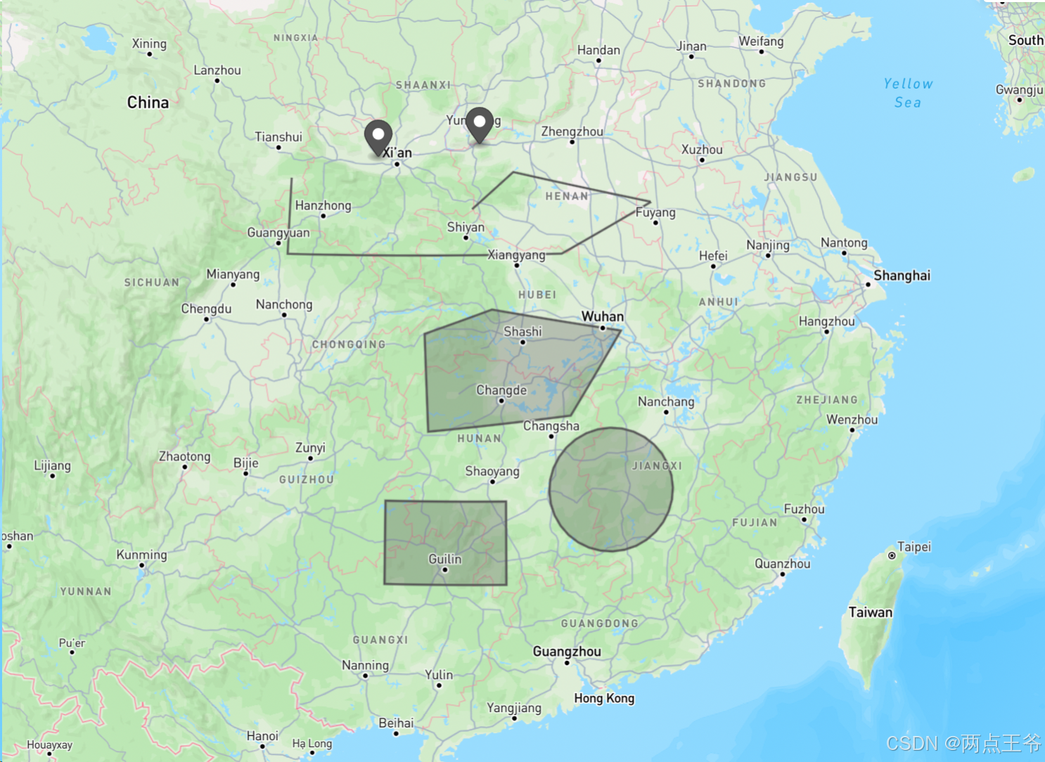
geojson文件内容:
{
  "type": "FeatureCollection",
  "features": [
    {
      "type": "Feature",
      "properties": {},
      "geometry": {
        "coordinates": [
          108.42059285538897,
          34.43175777680618
        ],
        "type": "Point"
      }
    },
    {
      "type": "Feature",
      "properties": {},
      "geometry": {
        "coordinates": [
          111.15959608531722,
          34.74576956006696
        ],
        "type": "Point"
      }
    },
    {
      "type": "Feature",
      "properties": {},
      "geometry": {
        "coordinates": [
          [
            106.11540367928148,
            33.91109288219454
          ],
          [
            106.11614709728264,
            32.20222171484548
          ],
          [
            108.56687126625343,
            32.21199643897913
          ],
          [
            113.29200530656033,
            32.26044556624461
          ],
          [
            115.71682073269943,
            33.36702730103086
          ],
          [
            112.0523114542068,
            34.09439185179981
          ],
          [
            110.95158929605105,
            33.26505021211912
          ]
        ],
        "type": "LineString"
      }
    },
    {
      "type": "Feature",
      "properties": {},
      "geometry": {
        "coordinates": [
          [
            [
              109.73894408656122,
              30.501331719180385
            ],
            [
              109.85604450474239,
              28.348034378250603
            ],
            [
              113.43162339245538,
              28.682911024734366
            ],
            [
              114.76736388663636,
              30.528086094570284
            ],
            [
              111.4658127739807,
              31.040201068612618
            ],
            [
              109.73894408656122,
              30.501331719180385
            ]
          ]
        ],
        "type": "Polygon"
      }
    },
    {
      "type": "Feature",
      "properties": {},
      "geometry": {
        "coordinates": [
          [
            [
              108.81149696296643,
              26.805083738957336
            ],
            [
              108.81149696296643,
              24.938673483978008
            ],
            [
              111.79210342158211,
              24.938673483978008
            ],
            [
              111.79210342158211,
              26.805083738957336
            ],
            [
              108.81149696296643,
              26.805083738957336
            ]
          ]
        ],
        "type": "Polygon"
      }
    },
    {
      "type": "Feature",
      "properties": {},
      "geometry": {
        "type": "Polygon",
        "coordinates": [
          [
            [
              114.41327342080456,
              28.390688695200648
            ],
            [
              114.2598987512277,
              28.383975751952153
            ],
            [
              114.1080578394897,
              28.363904106245688
            ],
            [
              113.95926732020769,
              28.330674555650916
            ],
            [
              113.81500985283358,
              28.284619259957868
            ],
            [
              113.67671780403441,
              28.22619802969625
            ],
            [
              113.54575771142683,
              28.155993214149294
            ],
            [
              113.4234157527747,
              28.074703269700738
            ],
            [
              113.31088441614443,
              27.98313510802512
            ],
            [
              113.20925053367442,
              27.88219533934431
            ],
            [
              113.11948480616361,
              27.772880538427156
            ],
            [
              113.04243290924884,
              27.65626667007572
            ],
            [
              112.97880823607287,
              27.53349781655032
            ],
            [
              112.92918629741655,
              27.405774351912804
            ],
            [
              112.89400076940365,
              27.274340707906045
            ],
            [
              112.87354115192251,
              27.1404728731205
            ],
            [
              112.8679519783689,
              27.005465762260297
            ],
            [
              112.87723349942844,
              26.870620585770503
            ],
            [
              112.90124375033986,
              26.73723234237224
            ],
            [
              112.93970190213702,
              26.60657754858957
            ],
            [
              112.99219279231522,
              26.479902310505853
            ],
            [
              113.05817252863386,
              26.358410834057835
            ],
            [
              113.1369750607291,
              26.243254461394585
            ],
            [
              113.22781961721812,
              26.135521312356662
            ],
            [
              113.32981891041645,
              26.036226602066268
            ],
            [
              113.44198801610243,
              25.946303698003263
            ],
            [
              113.56325384146727,
              25.866595972770742
            ],
            [
              113.6924651000978,
              25.79784950199156
            ],
            [
              113.82840271825316,
              25.74070665036505
            ],
            [
              113.96979060160737,
              25.695700582783626
            ],
            [
              114.11530669590213,
              25.663250731492724
            ],
            [
              114.26359427851854,
              25.643659244510534
            ],
            [
              114.41327342080456,
              25.637108434854714
            ],
            [
              114.56295256309056,
              25.643659244510534
            ],
            [
              114.711240145707,
              25.66325073149272
            ],
            [
              114.85675624000173,
              25.695700582783626
            ],
            [
              114.99814412335596,
              25.74070665036505
            ],
            [
              115.13408174151132,
              25.79784950199156
            ],
            [
              115.26329300014183,
              25.866595972770742
            ],
            [
              115.38455882550666,
              25.946303698003263
            ],
            [
              115.49672793119268,
              26.036226602066264
            ],
            [
              115.598727224391,
              26.135521312356662
            ],
            [
              115.68957178088,
              26.24325446139458
            ],
            [
              115.76837431297527,
              26.358410834057835
            ],
            [
              115.8343540492939,
              26.479902310505853
            ],
            [
              115.88684493947208,
              26.60657754858957
            ],
            [
              115.92530309126927,
              26.737232342372238
            ],
            [
              115.94931334218064,
              26.870620585770503
            ],
            [
              115.95859486324022,
              27.005465762260297
            ],
            [
              115.9530056896866,
              27.1404728731205
            ],
            [
              115.93254607220548,
              27.274340707906045
            ],
            [
              115.89736054419258,
              27.405774351912804
            ],
            [
              115.84773860553625,
              27.53349781655032
            ],
            [
              115.7841139323603,
              27.65626667007572
            ],
            [
              115.70706203544552,
              27.772880538427156
            ],
            [
              115.6172963079347,
              27.88219533934431
            ],
            [
              115.51566242546467,
              27.98313510802512
            ],
            [
              115.40313108883441,
              28.074703269700738
            ],
            [
              115.28078913018228,
              28.155993214149294
            ],
            [
              115.1498290375747,
              28.22619802969625
            ],
            [
              115.01153698877555,
              28.284619259957868
            ],
            [
              114.86727952140144,
              28.330674555650916
            ],
            [
              114.71848900211943,
              28.363904106245688
            ],
            [
              114.56664809038142,
              28.383975751952153
            ],
            [
              114.41327342080456,
              28.390688695200648
            ]
          ]
        ]
      }
    }
  ]
}
至此,就可以实现对shp文件的读取和解析了


 381
381

 被折叠的 条评论
为什么被折叠?
被折叠的 条评论
为什么被折叠?
 到【灌水乐园】发言


