


mounted() {
this.$nextTick(() => {
this.init()
})
},
methods: {
init() {
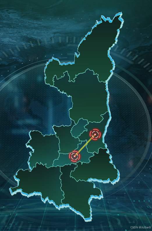
var myChart = this.$echarts.init(document.getElementById('shanximap'));
this.$echarts.registerMap("shanxi", shanxi);
let option = {
geo: [
{
map: "shanxi",
zoom: 1.1,
roam: true,
animation: false,
animationDurationUpdate: 0,
z: 2,
itemStyle: {
normal: {
color: {
type: "linear",
x: 0,
x2: 0,
y: 0,
y2: 1,
colorStops: [
{ offset: 0, color: "#10221E" },
{ offset: 0.9, color: "#184A35" },
],
},
borderWidth: 1, //分界线width
borderColor: "RGBA(140, 242, 222, 0.9)",
shadowColor: "RGBA(32, 180, 227, .3)", //阴影颜色
shadowBlur: 100, //阴影大小
// shadowOffsetX: 2, //沿x轴宽度
// shadowOffsetY: 2, //沿y轴宽度
borderCap: "square",
},
},
emphasis: {
label: {
show: false, //是否显示高亮
textStyle: {
color: "#fff",
fontSize: 15, //高亮放大字体
},
},
itemStyle: {
color: "#174C35",
},
},
},
{
map: "shanxi",
zoom: 1.12,
roam: true,
animation: false,
animationDurationUpdate: 0,
z: 1,
itemStyle: {
normal: {
color: {
type: "linear",
x: 0,
x2: 0,
y: 0,
y2: 1,
colorStops: [
{ offset: 0, color: "RGBA(15, 170, 227, 1)" },
{ offset: 0.9, color: "RGBA(14, 153, 229, .9)" },
],
},
borderWidth: 1, //分界线width
borderColor: "RGBA(255, 255, 255, 0.9)",
shadowColor: "RGBA(186, 236, 233, 1)", //阴影颜色
shadowBlur: 1, //阴影大小
shadowOffsetX: 2, //沿x轴宽度
shadowOffsetY: 5, //沿y轴宽度
borderCap: "square",
},
},
}
],
series: [
{
name: '故障',
type: 'scatter',
coordinateSystem: 'geo',
symbol: fault,
symbolSize: [50, 50],
data: [
{
name: '故障1',
value: [108.797426, 34.10671],
},
{
name: '故障2',
value: [109.856208, 34.950969],
}
]
},
{
name: '故障',
type: 'lines',
coordinateSystem: 'geo',
data: [
{
name: '西安',
coords: [
[108.797426, 34.10671],
[109.856208, 34.950969]
]
}
],
polyline: true,
lineStyle: {
color: '#FFF440',
opacity: 0.6,
width: 5
}
}
]
}
myChart.setOption(option, true);
window.onresize = function () {
myChart.resize();
};
myChart.off("georoam");
myChart.on("georoam", function (params) {
let option = myChart.getOption(); //获得option对象
if (params.zoom != null && params.zoom != undefined) {
//捕捉到缩放时
option.geo[1].zoom = option.geo[0].zoom + 0.02; //下层geo的缩放等级跟着上层的geo一起改变
option.geo[1].center = option.geo[0].center; //下层的geo的中心位置随着上层geo一起改变
} else {
//捕捉到拖曳时
option.geo[1].center = option.geo[0].center; //下层的geo的中心位置随着上层geo一起改变
}
myChart.setOption(option); //设置option
});
}
}


 687
687

 被折叠的 条评论
为什么被折叠?
被折叠的 条评论
为什么被折叠?
 到【灌水乐园】发言


