


 这篇博客介绍了如何使用OpenLayers库实现地图上的长度和面积测量功能。用户可以在地图上选择点来测量线段长度和多边形面积。计算基于几何球形长度和面积,但可能与实地测量有所不同,尤其是在Web Mercator投影中。博客提供了完整的HTML和JavaScript代码示例,展示了如何创建交互式的测量工具。
测量
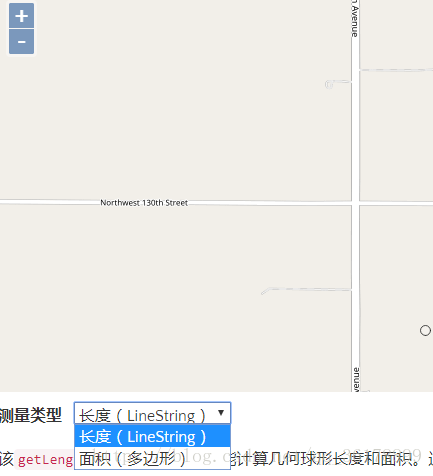
可以对地图进行操作,用户手动选择几个点,侧面积和测长度
该getLength()和getArea()功能计算几何球形长度和面积。通过假设几何坐标之间的大圆段来计算长度。计算面积,就好像多边形的边是大圆段一样。
请注意,geometry.getLength()和geometry.getArea()方法返回投影(平面)几何的度量。这些可能与某些情况下的实地测量非常不同 - 例如在使用Web Mercator的北部和南部纬度。为获得更好的结果,请使用ol/sphere模块中的功能。
<!DOCTYPE html><html>
<head>
<title>Measure</title>
<link rel="stylesheet" href="https://openlayers.org/en/v5.1.3/css/ol.css" type="text/css">
<!-- The line below is only needed for old environments like Internet Explorer and Android 4.x -->
<script src="https://cdn.polyfill.io/v2/polyfill.min.js?features=requestAnimationFrame,Element.prototype.classList,URL"></script>
<style>
.tooltip {
position: relative;
background: rgba(0, 0, 0, 0.5);
border-radius: 4px;
color: white;
padding: 4px 8px;
opacity: 0.7;
white-space: nowrap;
}
.tooltip-measure {
opacity: 1;
font-weight: bold;
}
.tooltip-static {
background-color: #ffcc33;
color: black;
border: 1px solid white;
}
.tooltip-measure:before,
.tooltip-static:before {
border-top: 6px solid rgba(0, 0, 0, 0.5);
border-right: 6px solid transparent;
border-left: 6px solid transparent;
content: "";
position: absolute;
bottom: -6px;
margin-left: -7px;
left: 50%;
}
.tooltip-static:before {
border-top-color: #ffcc33;
} </style>
</head>
<body>
<div id="map" class="map"></div>
<form class="form-inline">
<label>Measurement type </label>
<select id="type">
<option value="length">Length (LineString)</option>
<option value="area">Area (Polygon)</option>
</select>
</form>
<script>
import Map from 'ol/Map.js';
import { unByKey} from 'ol/Observable.js';
import Overlay from 'ol/Overlay.js';
import { getArea, getLength} from 'ol/sphere.js';
import View from 'ol/View.js';
import { LineString, Polygon
 最低0.47元/天 解锁文章


 1053
1053

 被折叠的 条评论
为什么被折叠?
被折叠的 条评论
为什么被折叠?
 到【灌水乐园】发言


