


Radar Installation
| Time Limit: 1000MS | Memory Limit: 10000K | |
| Total Submissions: 67259 | Accepted: 15091 |
Description
Assume the coasting is an infinite straight line. Land is in one side of coasting, sea in the other. Each small island is a point locating in the sea side. And any radar installation, locating on the coasting, can only cover d distance, so an island in the
sea can be covered by a radius installation, if the distance between them is at most d.
We use Cartesian coordinate system, defining the coasting is the x-axis. The sea side is above x-axis, and the land side below. Given the position of each island in the sea, and given the distance of the coverage of the radar installation, your task is to write a program to find the minimal number of radar installations to cover all the islands. Note that the position of an island is represented by its x-y coordinates.
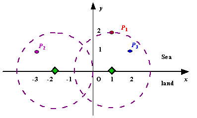
Figure A Sample Input of Radar Installations
We use Cartesian coordinate system, defining the coasting is the x-axis. The sea side is above x-axis, and the land side below. Given the position of each island in the sea, and given the distance of the coverage of the radar installation, your task is to write a program to find the minimal number of radar installations to cover all the islands. Note that the position of an island is represented by its x-y coordinates.
Figure A Sample Input of Radar Installations
Input
The input consists of several test cases. The first line of each case contains two integers n (1<=n<=1000) and d, where n is the number of islands in the sea and d is the distance of coverage of the radar installation. This is followed by n lines each containing
two integers representing the coordinate of the position of each island. Then a blank line follows to separate the cases.
The input is terminated by a line containing pair of zeros
The input is terminated by a line containing pair of zeros
Output
For each test case output one line consisting of the test case number followed by the minimal number of radar installations needed. "-1" installation means no solution for that case.
Sample Input
3 2
1 2
-3 1
2 1

1 2
0 2

0 0
Sample Output
Case 1: 2
Case 2: 1
反向考虑,把雷达建立到岛上,则其圆形区域与x轴相交的弦上每个点都可以放雷达侦测到这个岛屿,同理,求其他所有岛屿,按弦的左边坐标排序,把雷达建立到右点上,如果下一段的左端点大于前一个的右端点,则需要一个新的雷达,且雷达建立在这一段弦的右端点,如果下一段的左端点小于前一个的右端点,则不需要新建雷达,但是雷达的位置要改变到下一段的右端点,如此重复!
#include<cstdio>
#include<cstring>
#include<cmath>
#include<algorithm>
using namespace std;
struct node
{
	double l,r;
}s[1100];
bool cmp(node x,node y)
{
	return x.l<y.l;
}
int main()
{
	int m,i,j,cot=0,flag;
	double r,x,y;
	while(scanf("%d%lf",&m,&r),m+r)
	{
		int sum=1;
		flag=0;
		for(i=0;i<m;i++)
		{
			scanf("%lf%lf",&x,&y);
			s[i].l=x-sqrt(r*r-y*y);
			s[i].r=x+sqrt(r*r-y*y);
			if(y>r)
				flag=1;
		}
		if(flag)
		{
			printf("Case %d: -1\n",++cot);
			continue;
		}
		sort(s,s+m,cmp);
		int t=0;
		for(i=1;i<m;i++)
		{
			if(s[i].l>s[t].r)
			{
				sum++;
				t=i;
			}
			else if(s[i].r<=s[t].r)
				t=i;
		}
		printf("Case %d: %d\n",++cot,sum);
	}
	return 0;
 }


 413


 扫一扫


 被折叠的 条评论
为什么被折叠?
 到【灌水乐园】发言


