


 本文探讨了使用原生JS实现点击按钮关闭对应div功能时遇到的问题,详细解析了getElementById与getElementsByClassName的区别,提供了有效的解决方案。
问题描述
今天使用源生js实现 点击按钮关闭对应div功能(有多个按钮,相同class名),出现onclick无效情况。
问题原因
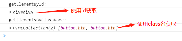
- 使用
getElementById获取元素的结果是:当前元素 - 使用
getElementsByClassName获取元素的结果是:相同class名元素数组。
解决办法
	var div = document.getElementById("div");
    console.log("getElementById: ");
    console.log(div);

    var btn = document.getElementsByClassName("btn");
    console.log("getElementsByClassName: ");
    console.log(btn);

    // 解决办法
    for(var i = 0;i < btn.length;i++){
       	btn[i].onclick=function(){
        	// 通过js实现div隐藏
	        div.style.display = "none";
        };
    }


 3923
3923

 被折叠的 条评论
为什么被折叠?
被折叠的 条评论
为什么被折叠?
 到【灌水乐园】发言


