


背景
在我们工作中,经常会遇到类似路径规划、知识图谱的需求,抽象出来即为图数据的处理,基于此,以下主要来分析图数据处理的算法
文中用到的库
import requests
import json
import re
import math
import networkx as nx
import matplotlib
import matplotlib.pyplot as plt
from collections import defaultdict

# 如果图中汉字无法显示,请参照如下配置
matplotlib.rcParams['font.sans-serif'] = ['SimHei']
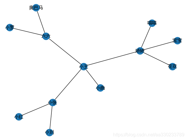
一、初始化(构造)图数据
def init_data1():
	'''
    初始化图数据
    :return: 返回字典,其key为某个人姓名,value为其认识的所有人
    '''
    init = {
        '小张': ['小刘', '小王', '小红'],
        '小王': ['六六', '娇娇', '小曲'],
        '娇娇': ['宝宝', '花花', '喵喵'],
        '六六': ['小罗', '奥巴马']
    }
    social_network = defaultdict(list)
    for key in init.keys():
        social_network[key] = init[key]
    return social_network
看看图长什么样的
social_network = init_data1()
social_network_graph = nx.Graph(social_network)
nx.draw(social_network_graph, with_labels=True)
plt.show()
二、图搜索
需求是通过某人认识某人,比如通过小张认识奥巴马,求其图路径
def search(graph, start, end):
    '''
    从图数据graph中,搜索start->end的所有路径
    :param graph: 图数据,格式如下:
    {
        '小张': ['小刘', '小王', '小红'],
        '小王': ['六六', '娇娇', '小曲'],
        '娇娇': ['宝宝', '花花', '喵喵'],
        '六六': ['小罗', '奥巴马']
    }
    :param start: 开始节点
    :param end: 结束节点
    :return: 所有路径列表
    '''
    check = [[start]]  # 搜索路径
    visited = set()  # 已访问过的节点
    finished = []
    while check:
        # 1、取一条未完成的搜索路径
        # 队列(广度优先搜索)
        path = check.pop(0)  # 取队列头
        # 栈(深度优先搜索)
        # paths = check.pop(-1)  # 取栈顶

        # 2、遍历该路径的下一层
        node = path[-1]
        # 如果节点已访问,则抛弃(本条路径),防止死循环
        if node in visited:
            continue
        # 遍历下一层
        for item in graph[node]:
            new_path = path + [item]

            if item == end:
                finished.append(new_path)  # 找到终点,则该路径结束搜索
            else:
                check.append(new_path)  # 否则将路径添加到搜索路径中
        visited.add(node)
    return finished
social_network = init_data1()
print(search(social_network, "小张", "奥巴马"))
打印结果:
[['小张', '小王', '六六', '奥巴马']]
三、实际应用
1、(最短)路径规划
以下代码只是为了说明主要功能,未考虑城市间河流问题(是否可达问题)
import re
import math
import networkx as nx
import matplotlib
import matplotlib.pyplot as plt
from collections import defaultdict
# 如果图中汉字无法显示,请参照如下配置
matplotlib.rcParams['font.sans-serif'] = ['SimHei']
def get_location():
"""
获取城市经纬度(这样的数据,在网络上很容易获得,主要为了方便说明主要原理,不再纠结数据源出处)
:return:
"""
coordination_source = """
{name:'兰州', geoCoord:[103.73, 36.03]},
{name:'嘉峪关', geoCoord:[98.17, 39.47]},
{name:'西宁', geoCoord:[101.74, 36.56]},
{name:'成都', geoCoord:[104.06, 30.67]},
{name:'石家庄', geoCoord:[114.48, 38.03]},
{name:'拉萨', geoCoord:[102.73, 25.04]},
{name:'贵阳', geoCoord:[106.71, 26.57]},
{name:'武汉', geoCoord:[114.31, 30.52]},
{name:'郑州', geoCoord:[113.65, 34.76]},
{name:'济南', geoCoord:[117, 36.65]},
{name:'南京', geoCoord:[118.78, 32.04]},
{name:'合肥', geoCoord:[117.27, 31.86]},
{name:'杭州', geoCoord:[120.19, 30.26]},
{name:'南昌', geoCoord:[115.89, 28.68]},
{name:'福州', geoCoord:[119.3, 26.08]},
{name:'广州', geoCoord:[113.23, 23.16]},
{name:'长沙', geoCoord:[113, 28.21]},
{name:'海口', geoCoord:[110.35, 20.02]},
{name:'沈阳', geoCoord:[123.38, 41.8]},
{name:'长春', geoCoord:[125.35, 43.88]},
{name:'哈尔滨', geoCoord:[126.63, 45.75]},
{name:'太原', geoCoord:[112.53, 37.87]},
{name:'西安', geoCoord:[108.95, 34.27]},
{name:'台湾', geoCoord:[121.30, 25.03]},
{name:'北京', geoCoord:[116.46, 39.92]},
{name:'上海', geoCoord:[121.48, 31.22]},
{name:'重庆', geoCoord:[106.54, 29.59]},
{name:'天津', geoCoord:[117.2, 39.13]},
{name:'呼和浩特', geoCoord:[111.65, 40.82]},
{name:'南宁', geoCoord:[108.33, 22.84]},
{name:'西藏', geoCoord:[91.11, 29.97]},
{name:'银川', geoCoord:[106.27, 38.47]},
{name:'乌鲁木齐', geoCoord:[87.68, 43.77]},
{name:'香港', geoCoord:[114.17, 22.28]},
{name:'澳门', geoCoord:[113.54, 22.19]}
"""
city = {}
for item in coordination_source.split('\n'):
city_name = re.findall(r'name:\'(.*)?\'', item)
location = re.findall(r'geoCoord:\[(\d+\.\d+).*\s(\d+\.\d+)\]', item)
if len(city_name) > 0 and len(location) > 0:
city[city_name[0]] = tuple(map(float, location[0]))
return city
def geo_distance(origin, destination):
"""
计算球面两点直线距离
Parameters
----------
origin : tuple of float
(lat, long)
destination : tuple of float
(lat, long)
Returns
-------
distance_in_km : float
Examples
--------
>>> origin = (48.1372, 11.5756) # Munich
>>> destination = (52.5186, 13.4083) # Berlin
>>> round(geo_distance(origin, destination), 1)
504.2
"""
lat1, lon1 = origin
lat2, lon2 = destination
radius = 6371 # km
dlat = math.radians(lat2 - lat1)
dlon = math.radians(lon2 - lon1)
a = (math.sin(dlat / 2) * math.sin(dlat / 2) +
math.cos(math.radians(lat1)) * math.cos(math.radians(lat2)) *
math.sin(dlon / 2) * math.sin(dlon / 2))
c = 2 * math.atan2(math.sqrt(a), math.sqrt(1 - a))
d = radius * c
return d
def get_city_distance(city, city1, city2):
"""
求两城市间距离
:param city:
:param city1:
:param city2:
:return:
"""
return geo_distance(city[city1], city[city2])
def get_connect(city):
"""
连接各城市节点
:param city:
:return:
"""
city_connect = defaultdict(list)
for key in city.keys():
for add in city.keys():
if add == key:
continue
if get_city_distance(city, key, add) < 1500:
city_connect[key].append(add)
return city_connect
def search(graph, start, end):
'''
从图数据graph中,搜索start->end的所有路径
:param graph: 图数据,格式如下:
{
'小张': ['小刘', '小王', '小红'],
'小王': ['六六', '娇娇', '小曲'],
'娇娇': ['宝宝', '花花', '喵喵'],
'六六': ['小罗', '奥巴马']
}
:param start: 开始节点
:param end: 结束节点
:return: 所有路径列表
'''
check = [[start]] # 搜索路径
visited = set() # 已访问过的节点
finished = []
while check:
# 1、取一条未完成的搜索路径
# 队列(广度优先搜索)
path = check.pop(0) # 取队列头
# 栈(深度优先搜索)
# paths = check.pop(-1) # 取栈顶
# 2、遍历该路径的下一层
node = path[-1]
# 如果节点已访问,则抛弃(本条路径),防止死循环
if node in visited:
continue
# 遍历下一层
for item in graph[node]:
new_path = path + [item]
if item == end:
finished.append(new_path) # 找到终点,则该路径结束搜索
else:
check.append(new_path) # 否则将路径添加到搜索路径中
visited.add(node)
return finished
def get_distance_by_path(path):
"""
求城市list的距离
:param path: ['兰州', '武汉', '上海']
:return: 距离
"""
distance = 0
for index, item in enumerate(path):
if index != 0:
distance += get_city_distance(get_location(), path[index - 1], item)
return distance
def sort_by_distance(paths):
"""
对所有path路径正序排序
:param paths: 多个路径[['兰州', '石家庄', '上海'], ['兰州', '武汉', '上海']]
:return: 排序后的list
"""
return sorted(paths, key=get_distance_by_path)
def init_data1():
'''
初始化一个简单的图数据
:return: 返回字典,其key为某个人姓名,value为其认识的所有人
'''
init = {
'小张': ['小刘', '小王', '小红'],
'小王': ['六六', '娇娇', '小曲'],
'娇娇': ['宝宝', '花花', '喵喵'],
'六六': ['小罗', '奥巴马']
}
social_network = defaultdict(list)
for key in init.keys():
social_network[key] = init[key]
return social_network
def init_data2():
"""
初始化城市图数据
:return:
"""
city = get_location()
city_connect = get_connect(city)
print(city_connect)
return city_connect
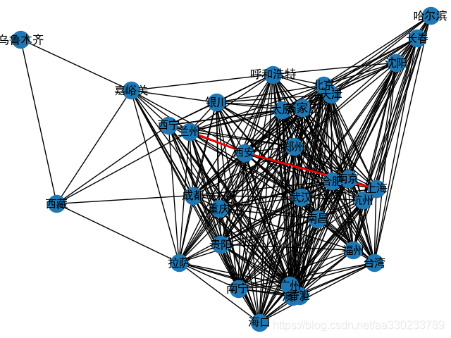
city_connect = init_data2() # 初始化城市图数据(数据获取方式与数据本身适用性不高,但足以说明思想要点)
result = search(city_connect, "兰州", "上海") # 搜索所有路径
print(result)
sorted = sort_by_distance(result) # 对路径排序(求最短路径)
for item in sorted:
print(get_distance_by_path(item), item)
打印
city_connect_graph = nx.Graph(city_connect)
nx.draw(city_connect_graph, get_location(), with_labels=True)
all_path = []
for index1, item1 in enumerate(sorted):
    if index1 < 1:
        for index2, item2 in enumerate(item1):
            if index2 != 0:
                all_path.append((item1[index2-1], item2))
print(all_path)
nx.draw_networkx_edges(city_connect_graph, get_location(), all_path, width=2, edge_color='r')
plt.show()
最短路径:兰州 —> 西安 —> 上海
[('兰州', '西安'), ('西安', '上海')]


 被折叠的 条评论
为什么被折叠?
被折叠的 条评论
为什么被折叠?
 到【灌水乐园】发言


